Du Val’s folio map of the slave forts of the Gulf of Guinea
£480
In stock
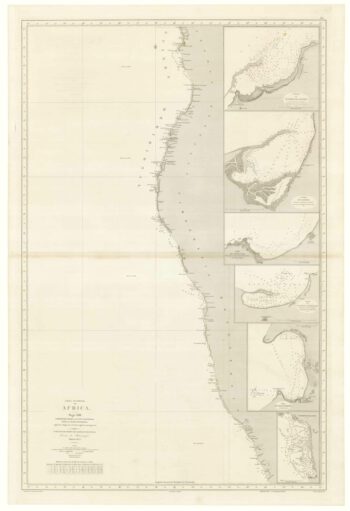
Du Val's scarce map of the coasts of Africa from Sierra Leone south to the Equator. Of interest is the early depiction of the mass of slaves forts that had sprung up on the Gold Coast (modern Ghana), including the infamous Elmina, Christiansborg and Cape Coast Castle (here Cabo-Corso). A key marks which were English, Dutch, Danish or Portuguese.
Issued in Du Val's atlas 'Cartes de Geographie'.
Additional information
| Dimensions | 530 × 340 mm |
|---|---|
| Cartographer | |
| Date | 1671 |
| Extra Info | Costes de Guin?e avec les Royaumes qui y sont connus des Europ?ens, au dedans des terres; Selon les Relations les plus nouvelles. |
| Publication | Paris, 1671. Old colour. 340 x 530mm. |
| Condition | A good example. |
| References | – |
Related Items
Related products
-

An uncommon Spanish sea chart of Gabon, the Congo and Angola
£700BREGANTE, S.
Published In 1870
Stock No. 18238 -

Mungo Park’s search for the River Niger
£500RENNELL, James.
Published In 1798
Stock No. 14251 -

Uncommon map of Congo and Angola
£280BLAEU, Johannes.
Published In 1705
Stock No. 20514 -

Italian map of the exploration of Central Africa
£80DOYEN.
Published In 1878
Stock No. 19381