The first appearance of the infamous ‘Mountains of Kong’
£420
Out of stock
A map of North Africa compiled by James Rennell to illustrate his appendix to Mungo Park's 'Travels in the Interior Districts of Africa', the account of Park's search for the source of the River Niger.
Under the patronage of Sir Joseph Banks and the African Association, Park travelled to Africa to seek the source of the River Niger (1795-7). His expedition was delayed by captivity and illness (he spent seven months convalescing in a man's home), and he was believed dead when he returned to Britain. Because Park had little experience as a cartographer, the job of compiling the maps for the official account fell to Major James Rennell (1742-1830), former cartographer to the East India Company in Bengal. He too had fallen foul of locals and had to retire from active service because of the wounds he had received. He became a research cartographer, pioneering oceanography. He used a variety of sources to compile this map and in doing so made his greatest cartographic error: he extrapolated a single mountain seen by Park into a huge range, creating the 'Mountains of Kong', running across West Africa. Such was Rennell's reputation that his theory was instantly accepted and the 'Mountains of Kong' blighted maps of Africa for most of the nineteenth century and occasionally beyond.
Additional information
| Cartographer | |
|---|---|
| Date | 1798 |
| Extra Info | A Map shewing the Progress of Discovery & Improvement, in the Geography of North Africa. |
| Publication | London: James Rennell, 1798. Some original outline colour. 430 x 725mm. |
| Condition | A good example. |
| References | – |
Related Items
Related products
-

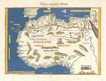
A famous 16th century woodblock map of North Africa
£850WALDSEEMULLER, Martin.
Published In 1541
Stock No. 23837 -

A mid-17th century map of north west Africa
£250SANSON, Nicolas.
Published In 1655
Stock No. 19737 -

18th century map of the Gold Coast of Africa
£150ANVILLE, Jean Baptiste B. D'.
Published In 1772
Stock No. 22018 -

Map of north west Africa with vignettes
£95TALLIS, John.
Published In 1851
Stock No. 16151