An 18th century map of the Americas
£550
In stock
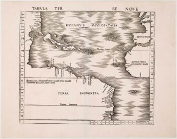
A scarce map of the Americas, published in Euler's 'Atlas Geographicus' under the auspices of the Prussian Royal Academy of Sciences, whose privilege stamp appears bottom right. Of interest is the North West Passage, which appears as a river running west from the Great Lakes to the Pacific
Leonhard Euler (1707-83). a Swiss mathematician, also helped prepare the 'Atlas Russicus' in St Petersburg, 1745. A very fine example.
Additional information
| Dimensions | 380 × 335 mm |
|---|---|
| Cartographer | |
| Date | 1753 |
| Extra Info | Tab: Geogr: Americ? ad emendatiora quae adhuc prodierunt exampla jussu Acad: Reg: Scient: et eleg litt: Boruss descripta. |
| Publication | Berlin, 1753. Original colour with addition to the cartouche. 335 x 380mm. |
| Condition | A good example. |
| References | – |
Related Items
Related products
-

One of the earliest maps to depict America
£42,500WALDSEEMULLER, Martin.
Published In 1513
Stock No. 24130 -

Blaeu’s famous carte à figure map of America
£5,000BLAEU, Willem Janszoon.
Published In 1650
Stock No. 22579 -

The Americas with California as an island
£1,600SEUTTER, Matthaus.
Published In 1730
Stock No. 18927 -
A scarce 16th century miniature map of America
£550LANGENES, Barent.
Published In 1599
Stock No. 21251