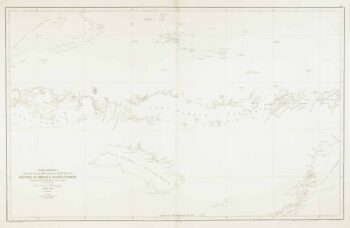
Spanish Sea chart of the Gaspar Strait
£450
In stock
Sea chart of the Gaspar Strait (Selat Gelasa), between the islands of Belitung and Bangka in Indonesia. As a connection between the Java Sea to the South China Sea it was an important route: an English ship had used it as early as 1702. Lighthouses are marked in colour.
Additional information
| Dimensions | 640 × 980 mm |
|---|---|
| Cartographer | |
| Date | 1862 |
| Extra Info | Mar de China. Carta del Estrecho de Gaspar segun la publicada por el Almiratazgo de Inglaterra en 1861. |
| Publication | Madrid: Direccion de Hidrografia, 1862. Touches of original colour. 980 x 640mm. Blind stamp of the Direccion de Hidrografia. |
| Condition | A good example. |
| References | – |
Related Items
Related products
-

18th century map of the Malay Peninsula and Indonesia
£600CHATELAIN, Henri Abraham.
Published In 1719
Stock No. 19983 -

Sea chart of the Lesser Sunda Islands
£500RIUDAVETS, José Maria.
Published In 1863
Stock No. 12460 -

The Strait of Malacca & Singapore
£475AA, Pieter van der.
Published In 1714
Stock No. 23646 -

Sea chart of the western Java Sea
£350DE LORENZO, J.
Published In 1863
Stock No. 12468