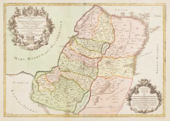
A 17th century influential map of the Holy Land
£600
In stock
Visscher's influential map of the Holy Land (copied by De Wit, Homann et al.), orientated with north to the right. The title is within a large cartouche with putti holding up garlands, and under the map is a plan of the camp of the Israelites during the Exodus.
Additional information
| Dimensions | 560 × 460 mm |
|---|---|
| Cartographer | |
| Date | 1659 |
| Extra Info | Terra Sancta, sive Promissionis, olim Palestina rences delineata, et in lucem edita per Nicolaum Visscher Anno 1659. |
| Publication | Amsterdam, c.1659. Old colour. 460 x 560mm. |
| Condition | A good example. |
| References | LAOR: 793. |
Related Items
Related products
-

Villalpando’s important large-scale plan of Jerusalem
£2,000VILLALPANDO, Juan Bautista.
Published In 1604
Stock No. 22075 -

An early woodcut map of the Holy Land
£850MUNSTER, Sebastian.
Published In 1552
Stock No. 24569 -

An early 17th century Dutch map of the Holy Land
£780HONDIUS, Jodocus.
Published In 1630
Stock No. 22575 -

18th century map of the Holy Land in fine colour
£450JAILLOT, Alexis-Hubert.
Published In 1781
Stock No. 14768