

A decorative wall map of England & Wales
£1,500
In stock
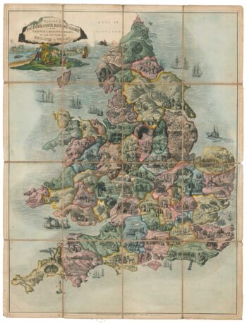
A detailed map of England and Wales in fine original colour, with regional boundaries, roads, railways, settlements and topography marked. Dedicated to William IV, it has a large vignette of Windsor Castle above the title, views of Westminster Abbey, York Minster, St Paul's and Canterbury Cathedral in the four corners, and 28 portraits of British worthies in the borders. Along the top are soldiers, including Marlborough and Wellington; down the left are politicians, including Fox, Pitt and Canning; down the right are intellectuals, including Shakespeare, Newton, Pope, Byron and Burns.
Additional information
| Dimensions | 940 × 1170 mm |
|---|---|
| Cartographer | |
| Date | 1835 |
| Publication | London, James Neele & Co, c.1835. Fine original colour. Dissected and laid on linen as issued, total 1170 x 940mm, with slipcase. |
| Condition | A good example. |
| References | – |
Related Items
Related products
-

Vrients’s scarce map of England, Wales & Ireland
£4,250VRIENTS, Jan Baptist.
Published In 1612
Stock No. 20271 -

A four-sheet wall map of England and Wales
£1,600KITCHIN, Thomas.
Published In 1792
Stock No. 16009 -
A Georgian ”goose game” of England and Wales
£1,200WALLIS, Edward.
Published In 1830
Stock No. 18380 -

North West England from the first English Edition of the ‘Atlas Minor’
£150HONDIUS, Jodocus.
Published In 1635
Stock No. 22445