A scarce issue of Speed’s map of Cheshire
£1,250
In stock
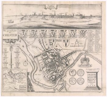
An important map of Cheshire, engraved by Jodocus Hondius for John Speed's county atlas, 'The Theatre of the Empire of Great Britain', first published 1611-12. It is one of the most decorative maps of the county with two royal crests held aloft by putti, armorials, a plan of Chester and galleons and sea-monsters around the Wirral. An English text on verso gives a history of the county and an extensive list of towns and villages.
Most of the Speed counties are derived from Saxton's maps: here Speed has used William Smith's revisions of Saxton, and the Braun & Hogenberg plan of Chester.
This example comes from the Roger Rea issue of the atlas, which was beset with disaster: according to an advert for the 1676 Bassett & Chiswell edition, ''the greatest part of an Impression, then newly Printed, [was] destroyed by the late dreadful Fire, 1666". Surviving examples of any Rea map are thus rare.
Additional information
| Dimensions | 505 × 380 mm |
|---|---|
| Cartographer | |
| Date | 1665 |
| Extra Info | The Countye Palatine of Chester with that most ancient Citie described. |
| Publication | London: Roger Rea & Son, 1665. Coloured. 380 x 505mm. |
| Condition | A good example. |
| References | – |
Related Items
Related products
-

A scarce 17th century plan and prospect of Chester
£750HOLLAR, Wenceslaus.
Published In 1668
Stock No. 23328 -

16th century map of Cheshire from the Duke of York’s Library
£460BLAEU, Johannes.
Published In 1648
Stock No. 15535 -

An uncommon 18th century miniature plan of Chester
£240DURY, Andrew.
Published In 1764
Stock No. 21424 -

A 17th century townplan of Chester
£175HERMANNIDES, Rutger.
Published In 1661
Stock No. 22785