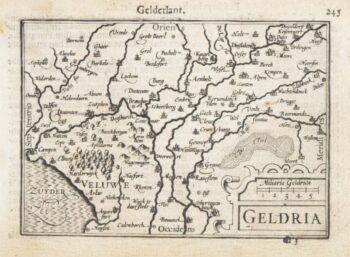
A 16th century miniature map of North Holland
£70
In stock
A scarce map of North Holland, engraved by either Pieter van den Keere or Jodocus Hondius for the 1598 'Caert-Thresoor', with a text by an unknown author. Despite being published a year after the first edition, this is a second state: the lateral borders have been re-engraved with latitude graduations.
By 1600 this map was being published in the 'Tabularum Geographicarum Contractarum' with a text by Petrus Bertius, and in 1616 a new plate was engraved by Jodocus Hondius II, slightly larger and with wider borders with scales of longitude and latitude.
Additional information
| Dimensions | 125 × 85 mm |
|---|---|
| Cartographer | |
| Date | 1599 |
| Extra Info | 1597. Hollandia Septen. |
| Publication | Amsterdam, Cornelis Claez, 1599, Dutch text edition. 85 x 125, with letterpress surtitle and pagination. |
| Condition | A good example. |
| References | – |
Related Items
Related products
-

18th century town plan of the Hague
£1,300SEUTTER, Matthaus.
Published In 1760
Stock No. 22693 -

17th century townplan of Haarlem
£750BLAEU, Johannes.
Published In 1649
Stock No. 22683 -

A 16th century miniature map of Holland
£85LANGENES, Barent.
Published In 1599
Stock No. 21158 -

A 16th century miniature map of Gelderland
£70LANGENES, Barent.
Published In 1599
Stock No. 21164