A map from Cook’s second visit to New Zealand
£170
Out of stock
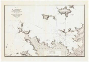
Chart of Resolution Harbour and Dusky Sound, on the south west of the South Island, New Zealand, drawn by Lieut. Henry Roberts (1756-796), who served with Cook on his Second and Third Voyages. Cook named Dusky Bay on his first voyage (1768-71), and returned there on his second (1772-5), spending two months exploring the fjord, planning its use as a harbour. Many of the names are still used, including Resolution Island and the unimaginative First, Second and Third Coves in Breakwater Sound. However there was a limit to their knowledge: below Third Sound is an 'Apparent Island' and, beneath that, a bay marked 'No body knows what'.
In 1791 George Vancouver, who had started his naval career as a midshipman on Cook's Second Voyage alongside Roberts, returned to Dusky Sound for re-provisioning en route to the American North West. Exploring the Sound further he reached the end of the southern bay: he could not resist adding to his map 'Somebody knows what', a joke that carried over to the published version.
Additional information
| Cartographer | |
|---|---|
| Date | 1777 |
| Extra Info | Sketch of Dusky Bay in New Zealand; 1773. |
| Publication | London: Strahan & Cadell, 1777. 225 x 380mm. |
| Condition | A good example. |
| References | – |
Related Items
Related products
-

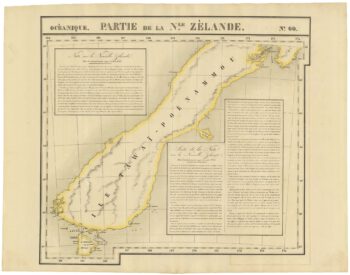
Zatta’s important map showing Cook’s charting of New Zealand
£1,750ZATTA, Antonio.
Published In 1778
Stock No. 24601 -

Unusual pair of large-format maps of New Zealand
£1,500VANDERMAELEN, Philippe.
Published In 1827
Stock No. 21699 -

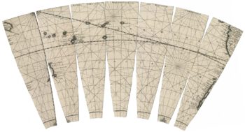
A rare set of seven globe gores of the Pacific with New Zealand
£1,500VALK, Gerard.
Published In 1707
Stock No. 23020 -

A detailed sea chart of the environs of Manawaora in New Zealand
£1,200DUPERREY, Louis-Isidore.
Published In 1829
Stock No. 23959