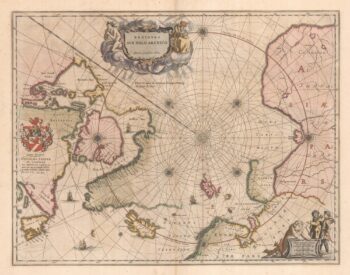
An Italian map of the Arctic Circle
£330
Out of stock
Add to WishlistRemove from Wishlist
Add to Wishlist
A map of the Northern Hemisphere down to the Tropic of Cancer. Northern California is shown, as an island; the mythical island of Friesland appears south west of Iceland; and 'Companie Land' is shown to the east of Kamtchatka.
Albrizzi was the first publisher to issue Tirion's maps: Tirion's own atlas was issued in Amsterdam in 1744.
Additional information
| Dimensions | 350 × 295 mm |
|---|---|
| Cartographer | |
| Date | 1740 |
| Extra Info | Nuova Carta del Polo Artico secondo l'ultime osservazioni. |
| Publication | Venice, Giovanni Battista Albrizzi, 1740. Coloured. 295 x 350mm. |
| Condition | A good example. |
| References | – |
Related Items
Related products
-

A 17th century Dutch sea chart of the North Atlantic
£1,350GOOS, Pieter.
Published In 1670
Stock No. 21871 -

A 17th century map of the early exploration of the Arctic Circle
£1,250BLAEU, Johannes.
Published In 1662
Stock No. 23200 -

Martin Frobisher’s voyage in search of the North West Passage
£650AA, Pieter van der.
Published In 1714
Stock No. 22079 -

Uncommon miniature map of Arctic
£180MULLER, Johann Ulrich.
Published In 1692
Stock No. 8946