- Reset all
- Abruzzo
- Adriatic Sea
- Advertising
- Aegean Islands
- Africa Continent
- Andalusia
- Australia
- Bahamas
- Bering Strait
- Bermuda
- Black Sea
- Bohemia
- Books about Maps
- British Isles Sea Charts
- Calabria
- Castille
- Central America
- China
- Corsica
- Crete
- Cuba
- Derbyshire
- Ecuador
- Emilia Romagna
- Europe
- Far East
- Finland
- Florida
- Gloucestershire
- Grenada
- Guadeloupe
- Herefordshire
- Hispaniola
- Holy Land
- Hungary
- Iceland
- India
- Ireland
- Ischia
- Isle of Wight
- Kent
- Leicestershire
- Leinster
- London Environs
- London Localities
- Luxembourg
- Marche
- Maritime
- Martinique
- Mexico
- Monaco
- New Zealand
- North Africa Maps
- North America
- Northumberland
- Oxfordshire
- Pacific and Australasia
- Pacific Ocean
- Pennsylvania
- Poland
- Portugal
- Prints
- Provence
- Reference Books
- Russia
- Scientific Instruments
- Scotland
- Somerset
- Southern Europe
- Southern Italy
- Spain
- St Kitts
- Staffordshire
- Surrey
- Sussex
- Syria
- The Guianas
- Ukraine
- United States Maps
- Views
- Wales
- Wiltshire
- Wind Roses
- Worcestershire
Showing 37–48 of 1700 results
-

A mid-18th century map of North America
£850LOTTER, Tobias Conrad.
Published In 1765
Stock No. 24610 -

A 17th century map of of the Mogol Empire
£700CANTELLI DA VIGNOLA, Giacomo.
Published In 1683
Stock No. 24609 -

16th century Dutch map of Switzerland
£800ORTELIUS, Abraham.
Published In 1575
Stock No. 21809 -

Nash’s planned layout of Regent Street
£980LUFFMAN, John.
Published In 1814
Stock No. 18274 -

John Nash’s remodelling of St James’s Park
£950MOGG, Edward.
Published In 1827
Stock No. 18193 -

A late-Georgian map of the environs of London
£650CRUCHLEY, George Frederick.
Published In 1827
Stock No. 15495 -

Woodblock map of Sumatra and the Malay Peninsula
£495MUNSTER, Sebastian.
Published In 1588
Stock No. 24584 -

16th century woodblock map of Silesia
£300MUNSTER, Sebastian.
Published In 1572
Stock No. 24582 -
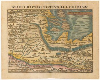
16th century woodblock map of Slovenia and Croatia
£375MUNSTER, Sebastian.
Published In 1572
Stock No. 24581 -

16th century woodblock map of France
£380MUNSTER, Sebastian.
Published In 1572
Stock No. 24580 -
Munster’s map of the Iberian Peninsula
£400MUNSTER, Sebastian.
Published In 1572
Stock No. 24579 -

A 16th century woodcut prospect of Rome
£400MUNSTER, Sebastian.
Published In 1572
Stock No. 24577