- Reset all
- Abruzzo
- Adriatic Sea
- Africa
- America Continent
- Atlases
- Balearics
- Balkan maps
- Barbary Coast
- Beijing
- Black Sea
- Books about Maps
- British Isles
- British Isles Maps
- Burma
- Calabria
- Campania
- Canary Islands
- Carolina
- Central America
- China
- Constantinople
- Cornwall
- Corsica
- Dorset
- Europe
- Gibraltar
- Greece
- Hispaniola
- Hungary
- Indian Ocean
- Leicestershire
- Lombardy
- London Environs
- Malta
- Map Collecting
- Maritime
- Monaco
- Moon
- Near East
- North America
- Norway
- Pacific and Australasia
- Panama
- Paris
- Prospects
- Provence
- Russia
- Shropshire
- Solar System
- Somerset
- South America
- Southern Europe
- Southern Italy
- Spain
- St Helena
- Staffordshire
- Suffolk
- Syria
- The Guianas
- Trentino
- Turkey
- Ukraine
- Virgin Islands
- Warwickshire
- West Indies
- Wiltshire
- Worcestershire
- World Maps
- Zodiac
Showing 37–48 of 2011 results
-

Ortelius’s map of Barbary in fine colour
£600ORTELIUS, Abraham.
Published In 1603
Stock No. 23807 -

A miniature double-hemisphere world.
£600SANSON, Nicolas.
Published In 1735
Stock No. 22316 -

The Russo-Turkish War in the Ukraine, 1735-39
£1,500OTTENS, Reinier & Joshua.
Published In 1736
Stock No. 24618 -
18th century decorative map of Italy
£550SEUTTER, Matth?us.
Published In 1740
Stock No. 24614 -

A mid-18th century map of North America
£850LOTTER, Tobias Conrad.
Published In 1765
Stock No. 24610 -

A 17th century Dutch map of the West Indies
£1,250VISSCHER, Nicolas.
Published In 1710
Stock No. 24608 -

16th century Dutch map of Switzerland
£800ORTELIUS, Abraham.
Published In 1575
Stock No. 21809 -

A late-Georgian map of the environs of London
£650CRUCHLEY, George Frederick.
Published In 1827
Stock No. 15495 -

16th century woodblock map of Silesia
£300MUNSTER, Sebastian.
Published In 1572
Stock No. 24582 -

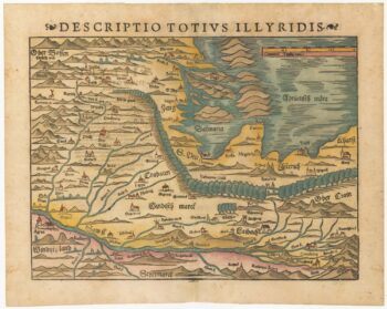
16th century woodblock map of Slovenia and Croatia
£375MUNSTER, Sebastian.
Published In 1572
Stock No. 24581 -

16th century woodblock map of France
£380MUNSTER, Sebastian.
Published In 1572
Stock No. 24580 -
Munster’s map of the Iberian Peninsula
£400MUNSTER, Sebastian.
Published In 1572
Stock No. 24579