- Reset all
- Abruzzo
- Adriatic Sea
- Allegorical maps
- Asia Continent
- Balearics
- Black Sea
- Books about Maps
- British Isles
- Calabria
- Central America
- China
- Constantinople
- Cornwall
- Cuba
- Europe
- France
- Gibraltar
- Greece
- Hispaniola
- Hungary
- Italy
- Latvia and Estonia
- London
- London Environs
- Maritime
- Monaco
- Moon
- Near East
- North Africa Maps
- North America
- Pacific and Australasia
- Paris
- Prospects
- Provence
- Russia
- Scandinavia
- Scientific Instruments
- Shropshire
- Somerset
- Southern Italy
- Spain
- St Helena
- St Kitts
- Syria
- Turkey
- Virgin Islands
- Warwickshire
- Wind Roses
- Worcestershire
- Zodiac
Showing 37–48 of 1733 results
-

A late-18th century plan of Vienna
£230ANDREWS, John.
Published In 1800
Stock No. 24512 -

Miniature map of Cyprus and the islands of the Aegean
£350HONDIUS, Jodocus II.
Published In 1610
Stock No. 24510 -

An early 17th century map of Iceland
£350HONDIUS, Jodocus.
Published In 1610
Stock No. 24509 -

Early 19th century plan of London
£350Anonymous.
Published In 1810
Stock No. 24505 -

The founding of St Petersburg by Peter the Great
£700ZATTA, Antonio.
Published In 1797
Stock No. 24504 -

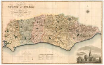
A large scale map of Sussex in fine colour
£2,800GREENWOOD, C. & J.
Published In 1825
Stock No. 24224 -

A scarce two-sheet map of England and Wales with side panels
£3,000WILLDEY, George.
Published In 1715
Stock No. 24165 -

A large scale map of Nottinghamshire in fine colour
£1,800SANDERSON, George.
Published In 1836
Stock No. 24067 -
An extremely rare example of the first printed plan of Exeter
£4,500HOOKER, John.
Published In 1587
Stock No. 24437 -

Chelsea from an important large-scale survey of London
£1,500HORWOOD, Richard.
Published In 1799
Stock No. 24403 -

A pictorial map of Beijing in the 1930s
£3,000DORN, Frank.
Published In 1936
Stock No. 24392 -

A map of the Russo-Turkish War of 1877-8
£250ILLUSTRATED LONDON NEWS.
Published In 1877
Stock No. 24378