- Reset all
- Abruzzo
- Adriatic Sea
- Allegorical maps
- Balearics
- Baltic Sea
- Black Sea
- Books about Maps
- British Isles
- Calabria
- Cambridgeshire
- Campania
- Central America
- China
- Constantinople
- Cornwall
- Durham
- Europe
- Gibraltar
- Greece
- Grenada
- Hispaniola
- Hungary
- Iberia
- Italy
- Latvia and Estonia
- London
- London Environs
- Maritime
- Monaco
- Moon
- Near East
- North Africa Maps
- North America
- Pacific and Australasia
- Panama
- Paris
- Prospects
- Provence
- Russia
- Scandinavia
- Scientific Instruments
- Shropshire
- Somerset
- Southern Italy
- Spain
- St Helena
- St Kitts
- Syria
- Turkey
- United States Maps
- Virgin Islands
- Warwickshire
- Wind Roses
- Worcestershire
- Zodiac
Showing 25–36 of 1776 results
-

Four scarce Italian playing cards depicting Poland
£850Anonymous.
Published In 1790
Stock No. 24241 -

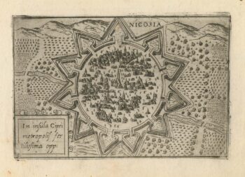
A 16th century town plan of Nicosia
£750VALEGIO, Francesco.
Published In 1598
Stock No. 24176 -

A scarce 17th century prospect of Villefranche-sur-Mer
£1,500BLAEU, Johannes.
Published In 1682
Stock No. 24159 -

A 16th century Italian plan of Buda
£600VALEGIO, Francesco.
Published In 1598
Stock No. 24150 -

A rare 16th century Italian plan of Famagusta
£950VALEGIO, Francesco.
Published In 1598
Stock No. 24148 -

Ortelius’s map of Barbary in fine colour
£600ORTELIUS, Abraham.
Published In 1603
Stock No. 23807 -

The First Issue of the iconic map of the London Underground, with overprinting
£2,600BECK, Henry C.
Published In 1933
Stock No. 24422 -

18th century decorative map of Italy
£550SEUTTER, Matth?us.
Published In 1740
Stock No. 24614 -

A mid-18th century map of North America
£850LOTTER, Tobias Conrad.
Published In 1765
Stock No. 24610 -

16th century Dutch map of Switzerland
£800ORTELIUS, Abraham.
Published In 1575
Stock No. 21809 -

Nash’s planned layout of Regent Street
£980LUFFMAN, John.
Published In 1814
Stock No. 18274 -

John Nash’s remodelling of St James’s Park
£950MOGG, Edward.
Published In 1827
Stock No. 18193