- Reset all
- Abruzzo
- Adriatic Sea
- Atlases
- Atlases and Books
- Black Sea
- Books about Maps
- British Isles
- British Isles Maps
- Calabria
- California
- Campania
- Canary Islands
- Caucasus
- Central America
- China
- Constantinople
- Constellations
- Cornwall
- Corsica
- Dorset
- Durham
- Gibraltar
- Greece
- Grenada
- Hispaniola
- Hungary
- Latvia and Estonia
- Lombardy
- London Environs
- Maritime
- Monaco
- Moon
- Morocco
- Near East
- North Africa Maps
- North America
- Norway
- Oxfordshire
- Pacific and Australasia
- Panama
- Paris
- Pictorial Maps
- Prospects
- Provence
- Russia
- Scientific Instruments
- Shropshire
- Somerset
- South America
- Spain
- St Helena
- Staffordshire
- Syria
- Turkey
- Virgin Islands
- War Maps
- Warwickshire
- Worcestershire
- Zodiac
Showing 25–36 of 1198 results
-

A scarce map of the Holy Land in the 18th century
£250FER, Nicolas de.
Published In 1707
Stock No. 24525 -

A scarce map of the Holy Land in Biblical times
£250FER, Nicolas de.
Published In 1707
Stock No. 24524 -

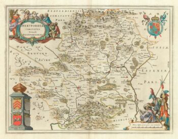
The uncommon Spanish edition of Blaeu’s map of Hertfordshire
£450BLAEU, Johannes.
Published In 1662
Stock No. 24521 -

John Oxley’s mapping of New South Wales
£280HALL, Sidney.
Published In 1828
Stock No. 24519 -

Seven scarce Italian playing cards depicting Russia
£480Anonymous.
Published In 1790
Stock No. 24360 -

Chart of the Zodiac sign Cancer
£275BLUNT, Charles F.
Published In 1845
Stock No. 24288 -

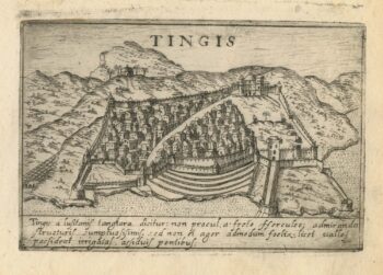
A 16th century town plan of Tangier
£220VALEGIO, Francesco.
Published In 1598
Stock No. 24217 -

A 16th century town plan of Casablanca
£240VALEGIO, Francesco.
Published In 1598
Stock No. 24215 -

A 16th century town plan of Rhodes
£250ROTA, Martin.
Published In 1598
Stock No. 24199 -

A 16th century town plan of Milan
£240VALEGIO, Francesco.
Published In 1598
Stock No. 24196 -

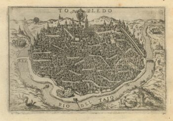
A 16th century town plan of Toledo
£250VALEGIO, Francesco.
Published In 1598
Stock No. 24189 -

A 16th century town plan of Santander
£260VALEGIO, Francesco.
Published In 1598
Stock No. 24188