- Reset all
- Abruzzo
- Advertising
- Aegean Islands
- Africa Continent
- Andalusia
- Australia
- Bering Strait
- Bermuda
- Black Sea
- Bohemia
- Books about Maps
- Calabria
- Central America
- China
- Corsica
- Cuba
- Ecuador
- Emilia Romagna
- Europe
- Finland
- Florida
- Grenada
- Hispaniola
- Hungary
- Iberia
- Iceland
- India
- Ireland
- Isle of Wight
- Kent
- Leicestershire
- London Environs
- Maritime
- Mexico
- Monaco
- Near East
- North Africa Maps
- North America
- North Europe Maps
- Northumberland
- Nottinghamshire
- Oxfordshire
- Pacific and Australasia
- Pacific Ocean
- Pennsylvania
- Poland
- Portugal
- Prints
- Provence
- Russia
- Scientific Instruments
- Scotland
- Somerset
- Spain
- Sri Lanka
- Staffordshire
- Surrey
- Sussex
- Syria
- Ukraine
- Umbria
- United States Maps
- Wales
- Wiltshire
- Worcestershire
Showing 25–36 of 1562 results
-

A 16th century Dutch map of Portugal
£700ORTELIUS, Abraham.
Published In 1595
Stock No. 24408 -

Four scarce Italian playing cards depicting Norway
£850Anonymous.
Published In 1790
Stock No. 24246 -

Four scarce Italian playing cards depicting Poland
£850Anonymous.
Published In 1790
Stock No. 24241 -

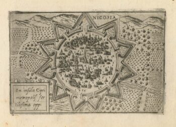
A 16th century town plan of Nicosia
£750VALEGIO, Francesco.
Published In 1598
Stock No. 24176 -

A scarce 17th century prospect of Villefranche-sur-Mer
£1,500BLAEU, Johannes.
Published In 1682
Stock No. 24159 -

A 16th century Italian plan of Buda
£600VALEGIO, Francesco.
Published In 1598
Stock No. 24150 -

A rare 16th century Italian plan of Famagusta
£950VALEGIO, Francesco.
Published In 1598
Stock No. 24148 -

Ortelius’s map of Barbary in fine colour
£600ORTELIUS, Abraham.
Published In 1603
Stock No. 23807 -

18th century decorative map of Italy
£550SEUTTER, Matth?us.
Published In 1740
Stock No. 24614 -

A mid-18th century map of North America
£850LOTTER, Tobias Conrad.
Published In 1765
Stock No. 24610 -

A 17th century map of of the Mogol Empire
£700CANTELLI DA VIGNOLA, Giacomo.
Published In 1683
Stock No. 24609 -

16th century Dutch map of Switzerland
£800ORTELIUS, Abraham.
Published In 1575
Stock No. 21809