
- Reset all
- Abruzzo
- Aegean Islands
- Africa Continent
- Azores
- Bering Strait
- Bermuda
- Black Sea
- Books about Maps
- Calabria
- Campania
- Canada
- Central America
- China
- Emilia Romagna
- Hispaniola
- Hungary
- Iceland
- Ireland
- Isle of Wight
- Leicestershire
- London Environs
- Marche
- Maritime
- Mexico
- Monaco
- Near East
- North America
- Oxfordshire
- Pacific and Australasia
- Pennsylvania
- Poland
- Portugal
- Prints
- Provence
- Russia
- Scientific Instruments
- Shropshire
- Somerset
- Spain
- Surrey
- Syria
- Ukraine
- United States Maps
- Veneto
Showing 1–12 of 719 results
-
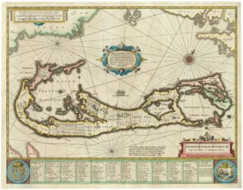
Richard Norwood’s map of Bermuda
£1,000HONDIUS, Henricus.
Published In 1633
Stock No. 24607 -

An unusual 18th century map of the Holy Land
£800SEUTTER, Matth?us.
Published In 1745
Stock No. 24605 -

Blaeu’s classic 17th century map of Iceland
£1,200BLAEU, Willem Janszoon.
Published In 1635
Stock No. 24604 -

Zatta’s important map showing Cook’s charting of New Zealand
£1,750ZATTA, Antonio.
Published In 1778
Stock No. 24601 -

A plan of Jerusalem after Adrichom
£750SEUTTER, Matth?us.
Published In 1730
Stock No. 24600 -

Map of Australia and New Zealand after Cook’s First Voyage to the Pacific
£1,000ZATTA, Antonio.
Published In 1776
Stock No. 24599 -

16th century woodblock prospect of Lisbon
£450MUNSTER, Sebastian.
Published In 1580
Stock No. 24586 -

A 16th century woodcut map of Poland, Lithuania and Hungary
£700MUNSTER, Sebastian.
Published In 1572
Stock No. 24574 -

An early woodcut map of the Holy Land
£850MUNSTER, Sebastian.
Published In 1552
Stock No. 24569 -

The English edition of Du Halde’s map of Guangdong
£1,600DU HALDE, Johann Baptiste.
Published In 1738
Stock No. 24558 -

A scarce 18th century map of the Polish-Lithuanian Commonwealth
£950NOLIN, Jean Baptiste jnr.
Published In 1742
Stock No. 24544 -

An 18th century map of North America
£1,200WEIGEL, Christoph.
Published In 1718
Stock No. 24541


