- Reset all
- Abruzzo
- Aegean Islands
- Africa Continent
- Barbary Coast
- Bering Strait
- Bermuda
- Black Sea
- Bohemia
- Bolivia
- Books about Maps
- Calabria
- Caspian Sea
- Celestial
- Central America
- Central Europe
- China
- Corsica
- Eastern Seaboard Maps
- Emilia Romagna
- Europe
- Falklands
- Finland
- Florida
- Gloucestershire
- Hispaniola
- Hungary
- Iberia
- Iceland
- India
- Ireland
- Ischia
- Isle of Wight
- Italy
- Kent
- Leicestershire
- London
- London Environs
- Luxembourg
- Madagascar
- Maritime
- Mexico
- Monaco
- Munster
- Near East
- North Africa Maps
- North America
- Oxfordshire
- Pacific and Australasia
- Pacific Ocean
- Pennsylvania
- Poland
- Portugal
- Prints
- Provence
- Reference Books
- Russia
- Scientific Instruments
- Scottish Counties
- Somerset
- Southern Italy
- Spain
- St Kitts
- Staffordshire
- Surrey
- Sussex
- Syria
- Ukraine
- United States Maps
- Wales
- Worcestershire
- World
- World and Continents
Showing 1741–1752 of 1843 results
-

Russia at the beginning of the reign of Peter the Great
£825DU VAL, Pierre.
Published In 1686
Stock No. 11447 -

17th century French map of Denmark
£200DU VAL, Pierre.
Published In 1686
Stock No. 11443 -

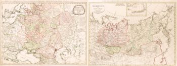
Two-sheet map of the Russian Empire
£1,200MANNERT, Konrad.
Published In 1794
Stock No. 11414 -

Holland with an Inset of its colonies in the East Indies
£280SEUTTER, Matthaus.
Published In 1744
Stock No. 11407 -

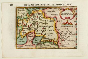
An early 17th century miniature map of Russia
£200BERTIUS, Petrus.
Published In 1603
Stock No. 11401 -

Luxembourg
£150SEUTTER, Matthaus.
Published In 1744
Stock No. 11397 -

18th century French chart of St Kitts
£300BELLIN, Jacques-Nicolas.
Published In 1764
Stock No. 11377 -

18th century map of Holstein
£200HOMANN, Johann Baptist.
Published In 1720
Stock No. 11370 -

Early 18th century map of Iberia
£160BION, Nicolas.
Published In 1710
Stock No. 11338 -

The Natural History of Norway, including sea-monsters!
£1,950PONTOPPIDAN, Erich.
Published In 1755
Stock No. 11264 -

A circular plan of London and Environs
£1,000PIGOT, James.
Published In 1832
Stock No. 11253 -

The first printed map of Corsica
£800BORDONE, Benedetto.
Published In 1534
Stock No. 11217