- Reset all
- Abruzzo
- Africa Continent
- Basque Regions
- Bering Strait
- Black Sea
- Books about Maps
- Calabria
- Campania
- China
- Connaught
- Emilia Romagna
- Hispaniola
- Hungary
- Ireland
- Leicestershire
- London Environs
- Maritime
- Monaco
- Near East
- New York
- North America
- Northern Europe
- Oxfordshire
- Pacific and Australasia
- Pennsylvania
- Poland
- Prints
- Provence
- Russia
- Scientific Instruments
- Serio-Comic
- Somerset
- Southern Italy
- Syria
- Ukraine
- United States Maps
- Worcestershire
- World
- Zodiac
Showing 1–12 of 733 results
-

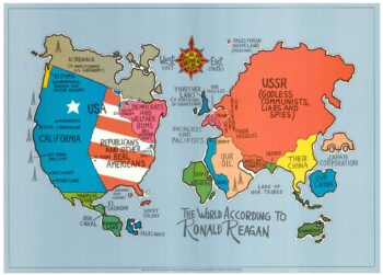
A serio-comic map satirising Ronald Reagan’s view of the World
£650HORSEY, David.
Published In 1984
Stock No. 24474 -
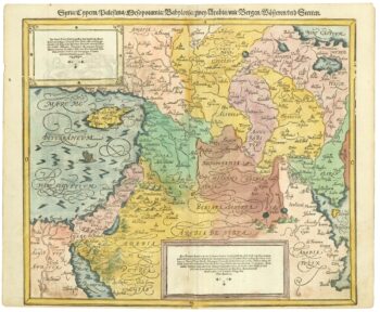
16th century map of the Eastern Mediterranean in rare early colour
£880MUNSTER, Sebastian.
Published In 1550
Stock No. 24441 -

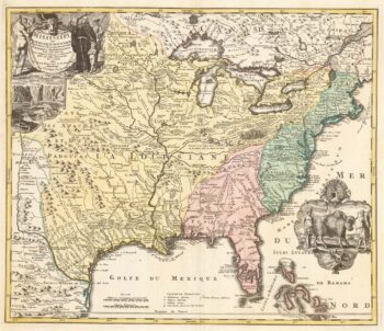
‘The Buffalo map’ of the Mississippi
£2,000HOMANN, Johann Baptist.
Published In 1720
Stock No. 24427 -

A Victorian game map of the world.
£5,500JONES, Thomas Henry.
Published In 1845
Stock No. 24423 -

Ruysch’s 1507 world map, with the earliest obtainable depiction of the Americas
£260,000RUYSCH, Johann.
Published In 1507
Stock No. 22807 -

A view of the Battle of Lepanto engraved in 1572
£2,500CAVALIERI, Giovanni Battista de'.
Published In 1647
Stock No. 24486 -

A Dutch satirical board game of the Second Boer War
£450SCHLETTE, E.G.
Published In 1900
Stock No. 24484 -

A rare lifetime printing of Blaeu’s view of Vesuvius erupting in 1631
£1,400BLAEU, Johannes.
Published In 1663
Stock No. 24506 -

A rare wall map of the Holy Land
£9,000NOLIN, Jean Baptiste.
Published In 1785
Stock No. 24500 -

One of the earliest world maps available to the collector
£15,000SCHEDEL, D. Hartmann.
Published In 1493
Stock No. 24528 -

An instructional card explaining shipboard directions
£220Anonymous.
Published In 1840
Stock No. 24472 -

London in the reign of William IV
£550SMITH, Charles.
Published In 1836
Stock No. 24428