- Reset all
- Abruzzo
- Africa
- African Islands
- Australia
- Balearics
- Benelux
- Bolivia
- Burma
- China
- Devon
- Far East Maps
- Ionian Islands
- Japan
- Lazio
- London Maps
- Malta
- Map Collecting
- Map Games
- Northamptonshire
- Old World
- Pacific Islands
- Pennsylvania
- Polar
- Scottish Towns
- Solar System
- Southern Europe
- Suffolk
- Switzerland
Showing 1–12 of 949 results
-

17th century map of the Sun
£1,850KIRCHER, Athanasius.
Published In 1665
Stock No. 24606 -

16th century woodblock prospect of Lisbon
£450MUNSTER, Sebastian.
Published In 1580
Stock No. 24586 -

Munster’s classic woodcut map of Italy
£850MUNSTER, Sebastian.
Published In 1572
Stock No. 24562 -

The English edition of Du Halde’s map of Guangdong
£1,600DU HALDE, Johann Baptiste.
Published In 1738
Stock No. 24558 -

A classic 16th century Dutch map of Italy
£1,400ORTELIUS, Abraham.
Published In 1572
Stock No. 24552 -

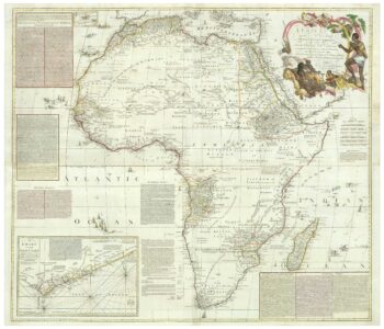
An 18th century wall map of Africa
£2,000ANVILLE, Jean Baptiste B. D'.
Published In 1772
Stock No. 24498 -

The Peutinger Table, one of the few surviving examples of Roman cartography
£2,000JANSSON, Jan.
Published In 1700
Stock No. 24492 -

16th century map of the Kingdom of Naples
£650ORTELIUS, Abraham.
Published In 1595
Stock No. 24444 -

A 16th century Dutch map of Portugal
£700ORTELIUS, Abraham.
Published In 1595
Stock No. 24408 -

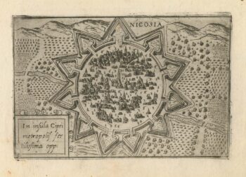
A 16th century town plan of Nicosia
£750VALEGIO, Francesco.
Published In 1598
Stock No. 24176 -

A rare 16th century Italian plan of Famagusta
£950VALEGIO, Francesco.
Published In 1598
Stock No. 24148 -

Ortelius’s map of Barbary in fine colour
£600ORTELIUS, Abraham.
Published In 1603
Stock No. 23807