Showing 1–12 of 535 results
-

17th century map of the Sun
£1,850KIRCHER, Athanasius.
Published In 1665
Stock No. 24606 -

The English edition of Du Halde’s map of Guangdong
£1,600DU HALDE, Johann Baptiste.
Published In 1738
Stock No. 24558 -

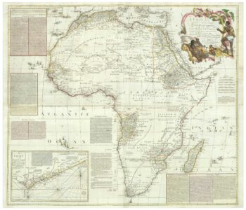
An 18th century wall map of Africa
£2,000ANVILLE, Jean Baptiste B. D'.
Published In 1772
Stock No. 24498 -

The Peutinger Table, one of the few surviving examples of Roman cartography
£2,000JANSSON, Jan.
Published In 1700
Stock No. 24492 -

Ortelius’s map of Barbary in fine colour
£600ORTELIUS, Abraham.
Published In 1603
Stock No. 23807 -

16th century Dutch map of Switzerland
£800ORTELIUS, Abraham.
Published In 1575
Stock No. 21809 -

A 16th century woodcut prospect of Rome
£400MUNSTER, Sebastian.
Published In 1572
Stock No. 24577 -

A 16th century woodcut map of Classical Rome
£220MUNSTER, Sebastian.
Published In 1572
Stock No. 24572 -
A 16th century woodcut map of Switzerland
£400MUNSTER, Sebastian.
Published In 1572
Stock No. 24570 -

18th century map of China
£320TIRION, Isaak.
Published In 1740
Stock No. 24547 -

A Victorian map of London illustating the famous buildings
£350SMITH, Charles & Son.
Published In 1871
Stock No. 24520 -

John Oxley’s mapping of New South Wales
£280HALL, Sidney.
Published In 1828
Stock No. 24519