- Reset all
- Abruzzo
- Antarctic
- Azores
- Bering Strait
- Black Sea
- Books about Maps
- Calabria
- Campania
- China
- Emilia Romagna
- Europe
- Germany
- Guadeloupe
- Hispaniola
- Hungary
- Ionian Islands
- Italy
- London Environs
- Maritime
- Monaco
- North America
- Oxfordshire
- Pacific and Australasia
- Pennsylvania
- Pictorial Maps
- Poland
- Polar
- Provence
- Scientific Instruments
- Scotland Maps
- Somerset
- Southern Italy
- Syria
- United States Maps
- West Indies Maps
- Worcestershire
- Zodiac
Showing 1225–1236 of 1258 results
-

Plan of Toulon in the mid-19th century
£75Society for the Diffusion of Useful Knowledge.
Published In 1836
Stock No. 9047 -

Miniature map of Dalmatia
£120ORTELIUS, Abraham.
Published In 1655
Stock No. 9016 -

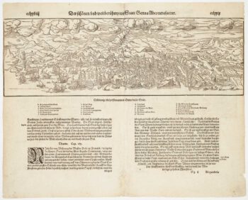
Incunable prospect of Pisa
£400SCHEDEL, D. Hartmann.
Published In 1493
Stock No. 8951 -

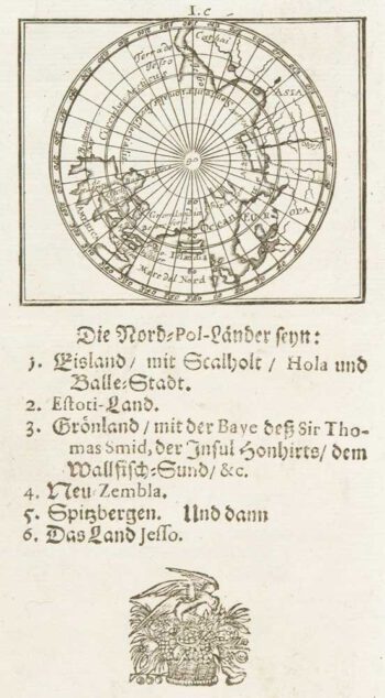
Uncommon miniature map of Arctic
£180MULLER, Johann Ulrich.
Published In 1692
Stock No. 8946 -

Uncommon miniature map of the West Indies
£175MULLER, Johann Ulrich.
Published In 1692
Stock No. 8928 -
Map of France celebrating the military successes of Louis XIV
£450LOTTER, Tobias Conrad.
Published In 1750
Stock No. 8717 -

Blue-Back Chart of the Bay of Biscay
£650STEEL & CO.
Published In 1813
Stock No. 9661 -

French Post Roads
£280LOTTER, Tobias Conrad.
Published In 1750
Stock No. 8713 -

Woodcut prospect of Genoa
£220MUNSTER, Sebastian.
Published In 1590
Stock No. 8633 -

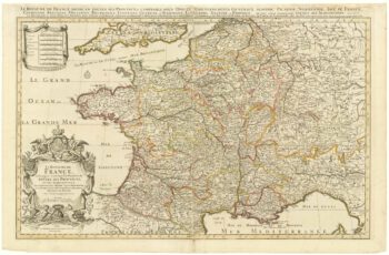
A two-sheet map of France
£700JAILLOT, Alexis-Hubert.
Published In 1705
Stock No. 8440 -

Friesland
£250JANSSON, Jan.
Published In 1666
Stock No. 8433 -

Guyenne
£240JANSSON, Jan.
Published In 1666
Stock No. 8391