Showing 1–12 of 373 results
-

Munster’s classic woodcut map of Italy
£850MUNSTER, Sebastian.
Published In 1572
Stock No. 24562 -

18th century map of the Eastern Seaboard
£750ROBERT DE VAUGONDY, Didier.
Published In 1770
Stock No. 24555 -

A classic 16th century Dutch map of Italy
£1,400ORTELIUS, Abraham.
Published In 1572
Stock No. 24552 -
18th century Italian map of the West Indies
£550CASSINI, Giovanni Maria.
Published In 1798
Stock No. 24532 -

16th century map of the Kingdom of Naples
£650ORTELIUS, Abraham.
Published In 1595
Stock No. 24444 -

18th century decorative map of Italy
£550SEUTTER, Matth?us.
Published In 1740
Stock No. 24614 -

A 17th century Dutch map of the West Indies
£1,250VISSCHER, Nicolas.
Published In 1710
Stock No. 24608 -
A 16th century woodcut prospect of Rome
£400MUNSTER, Sebastian.
Published In 1572
Stock No. 24577 -

A 16th century woodcut map of Classical Rome
£220MUNSTER, Sebastian.
Published In 1572
Stock No. 24572 -

The building of the Uptown Hudson Tubes in New York
£450Anonymous.
Published In 1890
Stock No. 24556 -

Vancouver’s mapping of the Pacific North West
£350VANCOUVER, Capt. George.
Published In 1820
Stock No. 24534 -

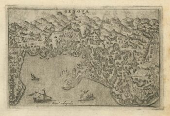
A 16th century town plan of Genova
£250VALEGIO, Francesco.
Published In 1598
Stock No. 24198