Showing 1–12 of 62 results
-

Map of Australia and New Zealand after Cook’s First Voyage to the Pacific
£1,000ZATTA, Antonio.
Published In 1776
Stock No. 24599 -

16th century woodblock map of Slovenia and Croatia
£375MUNSTER, Sebastian.
Published In 1572
Stock No. 24581 -

Seven scarce Italian playing cards depicting the Balkans and Greece
£480Anonymous.
Published In 1790
Stock No. 24361 -

A 16th century town plan of Dubrovnik
£250VALEGIO, Francesco.
Published In 1598
Stock No. 24175 -

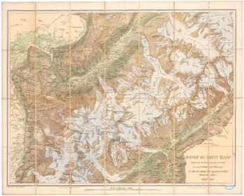
A detailed plan of the Mont-Blanc massif
£1,600BARBEY, Albert.
Published In 1924
Stock No. 22980 -

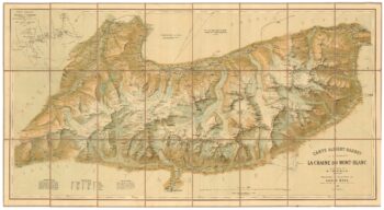
An important map of the Mont Blanc Massif
£950MIEULET, Jean-Joseph.
Published In 1865
Stock No. 24076 -

A mid-19th century map of Polynesia with decorative vignettes
£110TALLIS, John.
Published In 1851
Stock No. 21597 -

18th century illustration of a sundial
£160THOMAS, Corbinianus.
Published In 1730
Stock No. 21490 -

A 17th century illustration of an armillary sphere
£180MALLET, Alain Manesson.
Published In 1683
Stock No. 23928 -

A detailed Victorian map of Burma
£425ARROWSMITH, John.
Published In 1875
Stock No. 23852 -

The Venetian fort of San Nicolo, Sibenik
£350CORONELLI, Vincenzo Maria.
Published In 1700
Stock No. 23369 -

The Venetian city of Zadar in Croatia
£350CORONELLI, Vincenzo Maria.
Published In 1700
Stock No. 23367