- Reset all
- Abruzzo
- Bering Strait
- Black Sea
- Books about Maps
- Calabria
- Campania
- China
- Emilia Romagna
- Hispaniola
- Hungary
- Italy
- London Environs
- Maritime
- Monaco
- North America
- Northumberland
- Oxfordshire
- Pacific and Australasia
- Pennsylvania
- Pictorial Maps
- Poland
- Provence
- Russia
- Scientific Instruments
- Scotland Maps
- Somerset
- Southern Italy
- Sri Lanka
- Syria
- United States Maps
- Worcestershire
- Zodiac
Showing 1–12 of 630 results
-

A geological map of the Duchy of Tyrol
£2,350STOTTER, Michael.
Published In 1851
Stock No. 23050 -

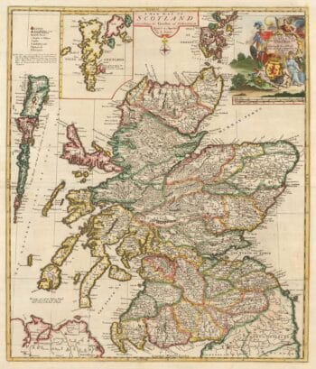
A scarce map of Scotland
£1,000BROWNE, Christopher.
Published In 1721
Stock No. 24436 -

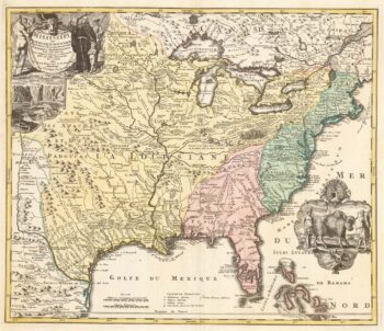
‘The Buffalo map’ of the Mississippi
£2,000HOMANN, Johann Baptist.
Published In 1720
Stock No. 24427 -

A view of the Battle of Lepanto engraved in 1572
£2,500CAVALIERI, Giovanni Battista de'.
Published In 1647
Stock No. 24486 -

A rare lifetime printing of Blaeu’s view of Vesuvius erupting in 1631
£1,400BLAEU, Johannes.
Published In 1663
Stock No. 24506 -

An instructional card explaining shipboard directions
£220Anonymous.
Published In 1840
Stock No. 24472 -

London in the reign of William IV
£550SMITH, Charles.
Published In 1836
Stock No. 24428 -

A two-sheet map of North America
£2,950JAILLOT, Alexis-Hubert.
Published In 1705
Stock No. 24062 -

Russia, from the first English atlas of the World
£2,200SPEED, John.
Published In 1676
Stock No. 23731 -

Victorian map of China with views of Hong Kong and Canton
£250TALLIS, John.
Published In 1851
Stock No. 23537 -

An 18th century city map and prospect of Florence
£1,350HOMANN HEIRS.
Published In 1731
Stock No. 24446 -

A two-sheet map of North America
£2,250JAILLOT, Alexis-Hubert.
Published In 1674
Stock No. 24482