Showing 1–12 of 26 results
-

A serio-comic map of Europe with the Russian octopus
£4,750GROSSI, Augusto.
Published In 1878
Stock No. 24393 -

The New Zealand gore from Coronelli’s 42 inch globe
£2,200CORONELLI, Vincenzo Maria.
Published In 1693
Stock No. 23716 -

A 16th century miniature map of Luxembourg
£70LANGENES, Barent.
Published In 1599
Stock No. 21155 -

A detailed sea chart of the environs of Waitangi in New Zealand
£1,250DUPERREY, Louis-Isidore.
Published In 1829
Stock No. 23961 -

A detailed sea chart of the environs of Manawaora in New Zealand
£1,200DUPERREY, Louis-Isidore.
Published In 1829
Stock No. 23959 -

A French serio-comic map of Europe for the Great War
£1,850CRETE, B.
Published In 1915
Stock No. 23347 -

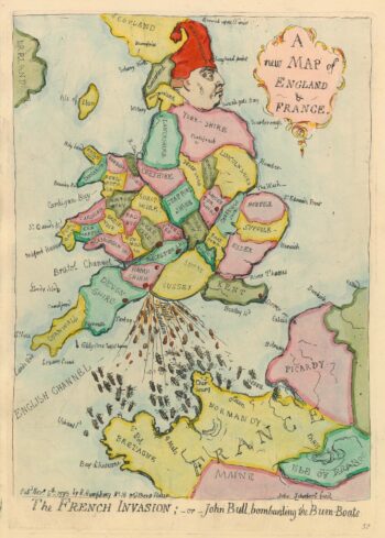
Caricature map of England in danger of invasion, from Gillray’s cruder output
£1,250GILLRAY, James.
Published In 1851
Stock No. 24158 -

A rare Italian serio-comic map of Europe in 1871
£20,000MANFREDO, Manfredi.
Published In 1871
Stock No. 23283 -

An Italian edition of Hadol’s serio-comic map of Europe
£1,200HADOL, Paul.
Published In 1888
Stock No. 23202 -

17th century plan of Luxembourg
£700BLAEU, Johannes.
Published In 1649
Stock No. 22685 -

An Italian Serio-Comic map of Europe during the Great War
£2,500Anonymous.
Published In 1915
Stock No. 22636 -

16th century map of Luxembourg
£500ORTELIUS, Abraham.
Published In 1592
Stock No. 20316