Showing 1–12 of 30 results
-

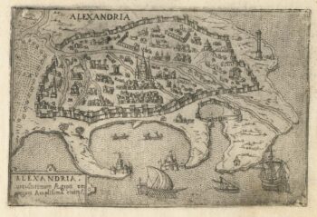
A 16th century Italian plan of Alexandria
£240VALEGIO, Francesco.
Published In 1598
Stock No. 24149 -

A map of the early Church in Egypt and Lybia
£650SANSON, Nicolas.
Published In 1704
Stock No. 24115 -

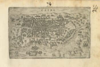
A 16th century Italian plan of Cairo
£250VALEGIO, Francesco.
Published In 1598
Stock No. 24146 -

A ‘bird’s-eye’ map of the Gordon Relief Mission, 1884
£1,750BACON, George Washington.
Published In 1885
Stock No. 24107 -

The scarce second state of the Lhuyd-Hondius map of Wales
£550LHUYD, Humfrey.
Published In 1638
Stock No. 23841 -

The first British atlas map of Wales
£1,700SPEED, John.
Published In 1665
Stock No. 23789 -

Decorative map of Egypt and the Nile
£450HOMANN, Johann Baptist.
Published In 1725
Stock No. 23263 -

Miniature map of Cardiganshire, Randorshire and Brecknockshire
£75PERROT, Aristide Michel.
Published In 1828
Stock No. 23106 -

Miniature map of Merionethshire and Montgomeryshire
£150PERROT, Aristide Michel.
Published In 1828
Stock No. 23105 -
Miniature map of map of Anglesey
£150PERROT, Aristide Michel.
Published In 1828
Stock No. 23073 -

Blaeu’s map of Pembrokeshire and Carmarthenshire, with fine colour
£500BLAEU, Johannes.
Published In 1662
Stock No. 23042 -

A 17th century townplan of Newport
£160HERMANNIDES, Rutger.
Published In 1661
Stock No. 22781