- Reset all
- Abyssinia
- Aegean Islands
- Africa Continent
- Argentina
- Balearics
- Barbary Coast
- Bering Strait
- Black Sea
- Bohemia
- Bolivia
- Books about Maps
- Calabria
- Central America
- Central Asia
- Central Europe
- Chile
- China
- Cornwall
- Corsica
- Denmark
- Eastern Seaboard Maps
- Emilia Romagna
- Europe
- Falklands
- Finland
- Florida
- Gloucestershire
- Hispaniola
- Hungary
- Iberia
- Iceland
- India
- Ireland
- Isle of Wight
- Italy
- Kent
- London
- London Environs
- Luxembourg
- Maritime
- Mexico
- Monaco
- Munster
- North Africa Maps
- North America
- North Europe Maps
- Northern Italy
- Northumberland
- Oxfordshire
- Pacific and Australasia
- Pacific Ocean
- Philippines
- Poland
- Portugal
- Prints
- Provence
- Reference Books
- Russia
- Scientific Instruments
- Somerset
- Southern Italy
- Spain
- St Petersburg
- Staffordshire
- Surrey
- Sussex
- Syria
- Ukraine
- United States Maps
- Wales
- Worcestershire
- World
- World and Continents
Showing 13–24 of 1665 results
-

A classic 16th century Dutch map of Italy
£1,400ORTELIUS, Abraham.
Published In 1572
Stock No. 24552 -

A late Victorian plan of Brighton.
£1,100TREACHER, H. & C.
Published In 1890
Stock No. 24546 -

A rare 18th century townplan of Worcester
£2,400YOUNG, George.
Published In 1780
Stock No. 24545 -

A scarce 18th century map of the Polish-Lithuanian Commonwealth
£950NOLIN, Jean Baptiste jnr.
Published In 1742
Stock No. 24544 -

A large and detailed 19th century map of India
£750WALKER, John.
Published In 1829
Stock No. 24543 -

An 18th century map of North America
£1,200WEIGEL, Christoph.
Published In 1718
Stock No. 24541 -

A detailed plan of Kensington Gardens and Hyde Park
£750ORDNANCE SURVEY.
Published In 1906
Stock No. 24529 -

A 17th century map of Poland
£750DE ROSSI, Giovanni Giacomo.
Published In 1685
Stock No. 24518 -

An 18th century map of the Caspian Sea
£700DE ROSSI, Domenico.
Published In 1723
Stock No. 24517 -

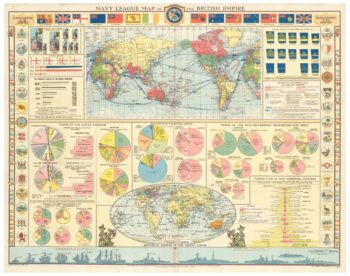
A map illustrating the British dominance of the seas
£450LONDON GEOGRAPHICAL INSTITUTE.
Published In 1922
Stock No. 24508 -

An 18th century wall map of Africa
£2,000ANVILLE, Jean Baptiste B. D'.
Published In 1772
Stock No. 24498 -

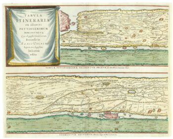
The Peutinger Table, one of the few surviving examples of Roman cartography
£2,000JANSSON, Jan.
Published In 1700
Stock No. 24492