Showing 1–12 of 43 results
-

A two-sheet map of North America
£2,950JAILLOT, Alexis-Hubert.
Published In 1705
Stock No. 24062 -

A two-sheet map of North America
£2,250JAILLOT, Alexis-Hubert.
Published In 1674
Stock No. 24482 -

A rare Italian edition of Hennepin’s landmark map of Louisiana
£2,800HENNEPIN, Louis.
Published In 1691
Stock No. 24027 -

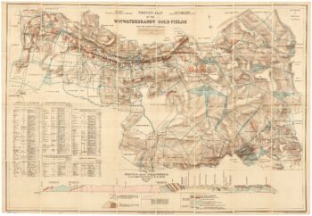
A scarce map of the gold rush near Johannesburg
£1,900TROYE, Gustav Arthur.
Published In 1892
Stock No. 24104 -

Cape of Good Hope naval prospect
£400AA, Pieter van der.
Published In 1719
Stock No. 24077 -

An aerial relief map of Afghanistan during the Great Game
£2,500JOHNSTON, W. & A.K.
Published In 1885
Stock No. 23565 -

18th century vue d’optique of the Cape of Good Hope
£600RIEDEL, Gottlieb Friedrich.
Published In 1780
Stock No. 23736 -
18th century map of Nubia and Abyssinia
£350CASSINI, Giovanni Maria.
Published In 1798
Stock No. 13313 -

The European colonies in North America in the 18th century
£1,400SEUTTER, Matthaus.
Published In 1735
Stock No. 24089 -

A Dutch edition of rhe first printed map to accurately plot the Mississippi River
£1,700DELISLE, Guillaume.
Published In 1722
Stock No. 23463 -
Early 17th century map of central Africa
£200HONDIUS, Jodocus.
Published In 1608
Stock No. 23220 -

Contemporary map of Transvaal on the cusp of the Second Boer War
£350STANFORD, Edward.
Published In 1899
Stock No. 22677