- Reset all
- Adriatic Sea
- Advertising
- Africa Continent
- America Continent
- Atlases
- Balearics
- Balkan maps
- Black Sea
- Books about Maps
- British Isles
- British Isles Maps
- Calabria
- Cambridgeshire
- Canary Islands
- Carolina
- Celestial
- Central America
- China
- Constantinople
- Cornwall
- Corsica
- Dorset
- Essex
- Gibraltar
- Globes and Instruments
- Greece
- Hispaniola
- Hungary
- Indian Ocean
- Lombardy
- London Environs
- Madeira
- Map Collecting
- Maritime
- Monaco
- Moon
- Near East
- North Africa Maps
- North America
- Norway
- Pacific and Australasia
- Panama
- Paris
- Polar
- Prospects
- Provence
- Russia
- Shropshire
- Solar System
- Somerset
- South America
- Southern Italy
- Spain
- St Helena
- Staffordshire
- Surrey
- Syria
- Texas
- Ukraine
- Veneto
- Virgin Islands
- Warwickshire
- Worcestershire
- World Maps
- Zodiac
Showing 13–24 of 1357 results
-

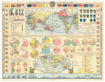
A map illustrating the British dominance of the seas
£450LONDON GEOGRAPHICAL INSTITUTE.
Published In 1922
Stock No. 24508 -

An 18th century wall map of Africa
£2,000ANVILLE, Jean Baptiste B. D'.
Published In 1772
Stock No. 24498 -

Facsimile of both Rocque’s 24 & 16-sheet map of London
£650ROCQUE, John.
Published In 1971
Stock No. 24478 -

Magini’s edition of Ptolemy’s Geography
£6,000MAGINI, Giovanni Antonio.
Published In 1598
Stock No. 24449 -

16th century map of the Kingdom of Naples
£650ORTELIUS, Abraham.
Published In 1595
Stock No. 24444 -

Four scarce Italian playing cards depicting Norway
£850Anonymous.
Published In 1790
Stock No. 24246 -

A scarce 17th century prospect of Villefranche-sur-Mer
£1,500BLAEU, Johannes.
Published In 1682
Stock No. 24159 -

A 16th century Italian plan of Buda
£600VALEGIO, Francesco.
Published In 1598
Stock No. 24150 -

Ortelius’s map of Barbary in fine colour
£600ORTELIUS, Abraham.
Published In 1603
Stock No. 23807 -

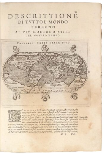
A miniature double-hemisphere world.
£600SANSON, Nicolas.
Published In 1735
Stock No. 22316 -

The Russo-Turkish War in the Ukraine, 1735-39
£1,500OTTENS, Reinier & Joshua.
Published In 1736
Stock No. 24618 -

A mid-18th century map of North America
£850LOTTER, Tobias Conrad.
Published In 1765
Stock No. 24610