- Reset all
- Adriatic Sea
- Advertising
- Antigua
- Argentina
- Asia
- Baltic Sea
- Bering Strait
- Bolivia
- British Isles
- Canada
- Canary Islands
- Devon
- Eastern Europe
- Eastern Seaboard Maps
- Elba
- Frontispieces
- Gulf States
- Hertfordshire
- Lancashire
- Latvia and Estonia
- Leicestershire
- Madeira
- Maritime
- Mexico
- Morocco
- Netherlands
- North America Maps
- Northamptonshire
- Nottinghamshire
- Poland
- Prints
- Scottish Islands
- Solar System
- St Kitts
- Switzerland
- Trentino
- United States
- Vietnam
- Virginia
- Westmorland
Showing 1–12 of 1110 results
-

17th century map of the Sun
£1,850KIRCHER, Athanasius.
Published In 1665
Stock No. 24606 -

An unusual 18th century map of the Holy Land
£800SEUTTER, Matth?us.
Published In 1745
Stock No. 24605 -

A plan of Jerusalem after Adrichom
£750SEUTTER, Matth?us.
Published In 1730
Stock No. 24600 -

16th century woodcut map of Sri Lanka as Taprobana
£500MUNSTER, Sebastian.
Published In 1574
Stock No. 24578 -

A 16th century woodcut map of Poland, Lithuania and Hungary
£700MUNSTER, Sebastian.
Published In 1572
Stock No. 24574 -

An early woodcut map of the Holy Land
£850MUNSTER, Sebastian.
Published In 1552
Stock No. 24569 -
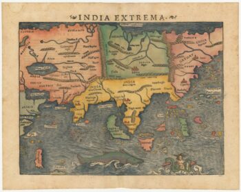
The first printed map of Asia
£1,850MUNSTER, Sebastian.
Published In 1572
Stock No. 24565 -

An early woodcut map of England
£1,000MUNSTER, Sebastian.
Published In 1572
Stock No. 24564 -

The English edition of Du Halde’s map of Guangdong
£1,600DU HALDE, Johann Baptiste.
Published In 1738
Stock No. 24558 -
18th century map of the Eastern Seaboard
£750ROBERT DE VAUGONDY, Didier.
Published In 1770
Stock No. 24555 -

A late Victorian plan of Brighton.
£1,100TREACHER, H. & C.
Published In 1890
Stock No. 24546 -

A rare 18th century townplan of Worcester
£2,400YOUNG, George.
Published In 1780
Stock No. 24545