- Reset all
- Adriatic Sea
- Andalusia
- Antarctic
- Antigua
- Atlases and Books
- Basque Regions
- Benelux
- Burma
- Central America
- China
- Falklands
- Gulf States
- Hertfordshire
- Holy Land
- Indian Ocean
- Liguria
- Luxembourg
- Maritime
- North Africa
- Northern Italy
- Sardinia
- Scandinavia
- Scientific Instruments
- Scottish Islands
- Singapore
- Somerset
- Texas
- Trentino
- West Indies
- Zodiac
Showing 1–12 of 504 results
-

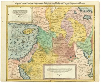
A geological map of the Duchy of Tyrol
£2,350STOTTER, Michael.
Published In 1851
Stock No. 23050 -

Ortelius’s pocket atlas with the Galle maps in fine colour
£14,000ORTELIUS, Abraham.
Published In 1595
Stock No. 24476 -

16th century map of the Eastern Mediterranean in rare early colour
£880MUNSTER, Sebastian.
Published In 1550
Stock No. 24441 -

A view of the Battle of Lepanto engraved in 1572
£2,500CAVALIERI, Giovanni Battista de'.
Published In 1647
Stock No. 24486 -

A rare two volume geographical lexicon
£17,500LASOR A VAREA, Alphonsus.
Published In 1713
Stock No. 24516 -

A rare wall map of the Holy Land
£9,000NOLIN, Jean Baptiste.
Published In 1785
Stock No. 24500 -

A very fine early 19th century miniature atlas
£2,250REMONDINI, Giuseppe Antonio.
Published In 1801
Stock No. 24527 -

An instructional card explaining shipboard directions
£220Anonymous.
Published In 1840
Stock No. 24472 -

An incunable prospect of Jerusalem
£1,600SCHEDEL, D. Hartmann.
Published In 1493
Stock No. 24425 -

A map of the early Church in Egypt and Lybia
£650SANSON, Nicolas.
Published In 1704
Stock No. 24115 -
Victorian map of China with views of Hong Kong and Canton
£250TALLIS, John.
Published In 1851
Stock No. 23537 -

A 16th century map of the colony of New Spain
£750ORTELIUS, Abraham.
Published In 1584
Stock No. 24448