- Reset all
- Adriatic Sea
- Andalusia
- Antarctic
- Antigua
- Basque Regions
- Benelux
- British Isles
- Buckinghamshire
- Burma
- Central America
- China
- Falklands
- Gulf States
- Hertfordshire
- Holy Land
- Indian Ocean
- Liguria
- Luxembourg
- Maritime
- North Africa
- Northern Italy
- Portugal
- Sardinia
- Scandinavia
- Scientific Instruments
- Scottish Islands
- Singapore
- Somerset
- Texas
- Trentino
- West Indies
- Zodiac
Showing 1–12 of 829 results
-

A geological map of the Duchy of Tyrol
£2,350STOTTER, Michael.
Published In 1851
Stock No. 23050 -

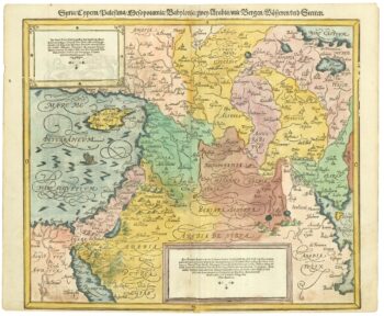
16th century map of the Eastern Mediterranean in rare early colour
£880MUNSTER, Sebastian.
Published In 1550
Stock No. 24441 -

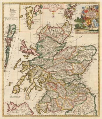
A scarce map of Scotland
£1,000BROWNE, Christopher.
Published In 1721
Stock No. 24436 -

Vrients’s scarce map of England, Wales & Ireland
£4,250VRIENTS, Jan Baptist.
Published In 1612
Stock No. 20271 -

A view of the Battle of Lepanto engraved in 1572
£2,500CAVALIERI, Giovanni Battista de'.
Published In 1647
Stock No. 24486 -

A monumental sea chart of south-west England
£3,250HOOGHE, Romeyn de.
Published In 1693
Stock No. 24483 -

A rare wall map of the Holy Land
£9,000NOLIN, Jean Baptiste.
Published In 1785
Stock No. 24500 -

An instructional card explaining shipboard directions
£220Anonymous.
Published In 1840
Stock No. 24472 -

An incunable prospect of Jerusalem
£1,600SCHEDEL, D. Hartmann.
Published In 1493
Stock No. 24425 -

A map of the early Church in Egypt and Lybia
£650SANSON, Nicolas.
Published In 1704
Stock No. 24115 -

An early 19th century map of Cornwall
£225CARY, John.
Published In 1805
Stock No. 24114 -
Victorian map of China with views of Hong Kong and Canton
£250TALLIS, John.
Published In 1851
Stock No. 23537