- Reset all
- Adriatic Sea
- Andalusia
- Antarctic
- Arabia
- Australia
- Benelux
- British Isles Maps
- Central America
- Dorset
- Eastern Europe
- Emilia Romagna
- Hertfordshire
- Indian Ocean
- Madeira
- Map Games
- North Africa
- Northern Italy
- Poland
- Scandinavia
- Scientific Instruments
- Scottish Islands
- Singapore
- Sri Lanka
- Suffolk
- Texas
- Wiltshire
- Wind Roses
Showing 1–12 of 485 results
-

Blaeu’s classic 17th century map of Iceland
£1,200BLAEU, Willem Janszoon.
Published In 1635
Stock No. 24604 -

16th century woodcut map of Sri Lanka as Taprobana
£500MUNSTER, Sebastian.
Published In 1574
Stock No. 24578 -

A 16th century woodcut map of Poland, Lithuania and Hungary
£700MUNSTER, Sebastian.
Published In 1572
Stock No. 24574 -

An early woodcut map of Scandinavia
£1,100MUNSTER, Sebastian.
Published In 1572
Stock No. 24567 -

A scarce 18th century map of the Polish-Lithuanian Commonwealth
£950NOLIN, Jean Baptiste jnr.
Published In 1742
Stock No. 24544 -

A 17th century map of Poland
£750DE ROSSI, Giovanni Giacomo.
Published In 1685
Stock No. 24518 -

Four scarce Italian playing cards depicting Norway
£850Anonymous.
Published In 1790
Stock No. 24246 -

Four scarce Italian playing cards depicting Poland
£850Anonymous.
Published In 1790
Stock No. 24241 -

Ortelius’s map of Barbary in fine colour
£600ORTELIUS, Abraham.
Published In 1603
Stock No. 23807 -
16th century woodblock map of Silesia
£300MUNSTER, Sebastian.
Published In 1572
Stock No. 24582 -

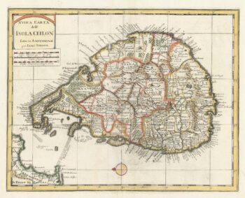
18th century map of Sri Lanka
£260TIRION, Isaak.
Published In 1740
Stock No. 24548 -

The uncommon Spanish edition of Blaeu’s map of Hertfordshire
£450BLAEU, Johannes.
Published In 1662
Stock No. 24521