- Reset all
- Adriatic Sea
- Andalusia
- Antarctic
- Arabia
- Australia
- Benelux
- British Isles Maps
- Central America
- Eastern Europe
- Emilia Romagna
- Hertfordshire
- Holy Land
- Indian Ocean
- Madeira
- Map Games
- North Africa
- Northern Italy
- Scandinavia
- Scientific Instruments
- Scottish Islands
- Singapore
- Sri Lanka
- Suffolk
- Texas
- Wiltshire
- Wind Roses
Showing 13–24 of 462 results
-

A 16th century Italian plan of Cairo
£250VALEGIO, Francesco.
Published In 1598
Stock No. 24146 -

A ‘bird’s-eye’ map of the Gordon Relief Mission, 1884
£1,750BACON, George Washington.
Published In 1885
Stock No. 24107 -

Speed’s famous map of the Saxon Heptarchy
£2,900SPEED, John.
Published In 1665
Stock No. 23788 -

Set of three gores covering Australia from Coronelli’s 42 inch globe
£4,500CORONELLI, Vincenzo Maria.
Published In 1693
Stock No. 23726 -

The Colombian Canal, an alternative scheme to Panama
£1,600PUYDT, Lucien de.
Published In 1871
Stock No. 24108 -

A detailed 19th century survey of South Australia
£950HARRIS, W.G.
Published In 1862
Stock No. 24105 -

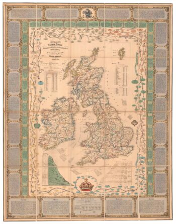
A Victorian educational map of the British Isles
£1,700STARK, J.
Published In 1851
Stock No. 24080 -

Folding map of Australia with fine colour
£980WYLD, James.
Published In 1833
Stock No. 24071 -

The most important prospect of Brescia
£18,000CARBONI, Domenico.
Published In 1764
Stock No. 23648 -

A 17th century sea chart of the Gulf of Aden in Dudley’s unique style
£3,250DUDLEY, Robert.
Published In 1646
Stock No. 23592 -

An impressive 16th century two-sheet plan of Antwerp
£1,500HOEFNAGEL, Joris.
Published In 1596
Stock No. 23372 -

Detailed folding map of the ‘Patriotic War of 1812’
£550VALLARDI, Guiseppe and Pietro.
Published In 1808
Stock No. 22675