- Reset all
- Adriatic Sea
- Andalusia
- Antarctic
- Australia
- Benelux
- Central America
- Eastern Europe
- Emilia Romagna
- Falklands
- Hertfordshire
- Holy Land
- Madeira
- Map Games
- Morocco
- Northern Italy
- Pacific Islands
- Piedmont
- Scientific Instruments
- Scottish Islands
- Singapore
- Sri Lanka
- Texas
- Ulster
- Virginia
- Wiltshire
- Wind Roses
Showing 1–12 of 378 results
-

An unusual 18th century map of the Holy Land
£800SEUTTER, Matth?us.
Published In 1745
Stock No. 24605 -

A plan of Jerusalem after Adrichom
£750SEUTTER, Matth?us.
Published In 1730
Stock No. 24600 -

16th century woodcut map of Sri Lanka as Taprobana
£500MUNSTER, Sebastian.
Published In 1574
Stock No. 24578 -

An early woodcut map of the Holy Land
£850MUNSTER, Sebastian.
Published In 1552
Stock No. 24569 -

17th century prospect of Biblical Jerusalem
£1,000DAPPER, Olfert.
Published In 1677
Stock No. 24540 -
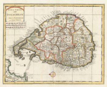
18th century map of Sri Lanka
£260TIRION, Isaak.
Published In 1740
Stock No. 24548 -

A scarce map of the Holy Land in the 18th century
£250FER, Nicolas de.
Published In 1707
Stock No. 24525 -

A scarce map of the Holy Land in Biblical times
£250FER, Nicolas de.
Published In 1707
Stock No. 24524 -

The uncommon Spanish edition of Blaeu’s map of Hertfordshire
£450BLAEU, Johannes.
Published In 1662
Stock No. 24521 -

John Oxley’s mapping of New South Wales
£280HALL, Sidney.
Published In 1828
Stock No. 24519 -

Seven scarce Italian playing cards depicting Russia
£480Anonymous.
Published In 1790
Stock No. 24360 -

A 16th century town plan of Tangier
£220VALEGIO, Francesco.
Published In 1598
Stock No. 24217