Showing 1–12 of 383 results
-

Zatta’s important map showing Cook’s charting of New Zealand
£1,750ZATTA, Antonio.
Published In 1778
Stock No. 24601 -

16th century woodblock prospect of Lisbon
£450MUNSTER, Sebastian.
Published In 1580
Stock No. 24586 -

16th century woodcut map of Sri Lanka as Taprobana
£500MUNSTER, Sebastian.
Published In 1574
Stock No. 24578 -

A large and detailed 19th century map of India
£750WALKER, John.
Published In 1829
Stock No. 24543 -

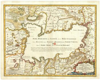
An 18th century map of the Caspian Sea
£700DE ROSSI, Domenico.
Published In 1723
Stock No. 24517 -

16th century map of the Kingdom of Naples
£650ORTELIUS, Abraham.
Published In 1595
Stock No. 24444 -

A 16th century Dutch map of Portugal
£700ORTELIUS, Abraham.
Published In 1595
Stock No. 24408 -

Ortelius’s map of Barbary in fine colour
£600ORTELIUS, Abraham.
Published In 1603
Stock No. 23807 -

A 17th century map of of the Mogol Empire
£700CANTELLI DA VIGNOLA, Giacomo.
Published In 1683
Stock No. 24609 -

Munster’s map of the Iberian Peninsula
£400MUNSTER, Sebastian.
Published In 1572
Stock No. 24579 -

A detailed map of Northern India
£300TARDIEU, Ambroise.
Published In 1780
Stock No. 24559 -

An early 19th century map of India.
£240POIRSON, J.B.
Published In 1803
Stock No. 24554