Showing 25–36 of 112 results
-

18th century map of New England and New York in original colours
£380BELLIN, Jacques-Nicolas.
Published In 1773
Stock No. 23227 -

Sea chart of south east Ireland with an inset of Dublin Bay
£550SELLER, Jeremiah.
Published In 1750
Stock No. 23160 -

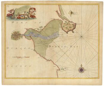
Sea chart of Dublin Bay from the first English sea-atlas
£550COLLINS, Greenvile.
Published In 1693
Stock No. 23156 -

Plan of Moscow at the beginning of the 19th century
£1,500JEAN, Pierre.
Published In 1801
Stock No. 22711 -

Miniature map of Tipperary
£100PERROT, Aristide Michel.
Published In 1828
Stock No. 23132 -

Miniature map of Cork
£100PERROT, Aristide Michel.
Published In 1828
Stock No. 23131 -

Miniature map of Kerry
£110PERROT, Aristide Michel.
Published In 1828
Stock No. 23130 -

Miniature map of Limerick
£100PERROT, Aristide Michel.
Published In 1828
Stock No. 23129 -

Miniature map of Galway
£110PERROT, Aristide Michel.
Published In 1828
Stock No. 23128 -

Miniature map of Longford and West Meath
£100PERROT, Aristide Michel.
Published In 1828
Stock No. 23127 -

Miniature map of East Meath
£110PERROT, Aristide Michel.
Published In 1828
Stock No. 23126 -

Miniature map of Dublin
£110PERROT, Aristide Michel.
Published In 1828
Stock No. 23125