Showing all 9 results
-

A 17th century map of Calabria
£440BLAEU, Johannes.
Published In 1644
Stock No. 21965 -

A 17th century Dutch sea chart of the Adriatic
£800GOOS, Pieter.
Published In 1660
Stock No. 21024 -

A chart of the Hong River, marking Hanoi
£100BELLIN, Jacques-Nicolas.
Published In 1764
Stock No. 20809 -

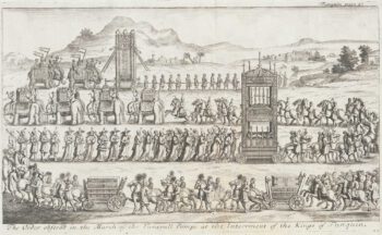
17th century Illustration of Tunquin
£180TAVERNIER, Jean-Baptiste.
Published In 1678
Stock No. 19921 -

17th century Illustration of King of Tunquin
£160TAVERNIER, Jean-Baptiste.
Published In 1678
Stock No. 19920 -

17th century Illustration of Tunquin Dignitaries
£190TAVERNIER, Jean-Baptiste.
Published In 1678
Stock No. 19919 -

17th century Illustration of Temples and Pagodas in Tunquin
£190TAVERNIER, Jean-Baptiste.
Published In 1678
Stock No. 19917 -
17th century Illustration of Temples and Pagodas in Tunquin
£180TAVERNIER, Jean-Baptiste.
Published In 1678
Stock No. 19916 -

Complete set of six maps of Calabria from the ‘Atlante Geografico del Regno di Napoli’
£650RIZZI-ZANNONI, Giovanni Antonio.
Published In 1812
Stock No. 15474