
- Reset all
- Advertising
- Argentina
- Bering Strait
- Bolivia
- British Isles
- Canada
- Canary Islands
- Devon
- Eastern Europe
- Eastern Seaboard Maps
- Egypt
- Elba
- Frontispieces
- Gulf States
- Hertfordshire
- Lancashire
- Latvia and Estonia
- Leicestershire
- Madeira
- Maritime
- Morocco
- Netherlands
- North America Maps
- Northamptonshire
- Norway
- Nottinghamshire
- Poland
- Prints
- Russia
- Scottish Islands
- Solar System
- Switzerland
- Trentino
- United States
- Vietnam
- Virginia
- Westmorland
- World and Continents
Showing 697–708 of 727 results
-

Holland with an Inset of its colonies in the East Indies
£280SEUTTER, Matthaus.
Published In 1744
Stock No. 11407 -
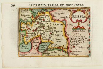
An early 17th century miniature map of Russia
£200BERTIUS, Petrus.
Published In 1603
Stock No. 11401 -

The road from Bagshot to Southampton and on to Salisbury
£380OGILBY, John.
Published In 1675
Stock No. 11367 -

The Natural History of Norway, including sea-monsters!
£1,950PONTOPPIDAN, Erich.
Published In 1755
Stock No. 11264 -

The English colonies on the north-east seaboard of America
£1,450HOMANN, Johann Baptist.
Published In 1725
Stock No. 11207 -

Miniature map of Holland
£140DU VAL, Pierre.
Published In 1682
Stock No. 10859 -
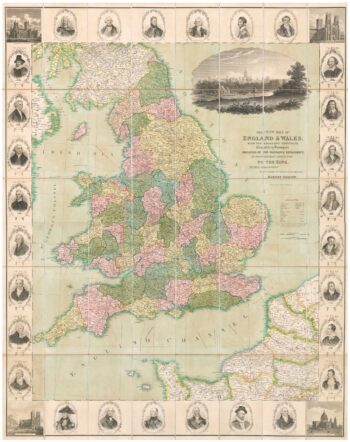
A decorative wall map of England & Wales
£1,500SEATON, Robert.
Published In 1835
Stock No. 10838 -

An impressive three-sheet map of the Russian Empire
£2,950TRESCOTT, John & SCHMIDT, Jakob.
Published In 1782
Stock No. 10643 -

Four-sheet folding map of England & Wales
£800CREIGHTON, R.
Published In 1839
Stock No. 10621 -

An Anglo-Dutch separate-issue road map of England
£480VISSCHER, Nicolas.
Published In 1694
Stock No. 10557 -

Madeira
£150BELLIN, Jacques-Nicolas.
Published In 1746
Stock No. 10178 -

Virginia & Florida
£1,350BLAEU, Willem Janszoon.
Published In 1647
Stock No. 10145