Showing 1–12 of 13 results
-

An Air France poster map of the world in a double hemisphere
£1,900BOUCHER, Lucien.
Published In 1950
Stock No. 23336 -

A scarce 17th century French map of Martinique
£400MARIETTE, Pierre.
Published In 1650
Stock No. 21841 -

Map of Martinique
£200RASPE, Gabriel Nikolaus.
Published In 1762
Stock No. 19677 -

18th century map of Martinique in fine colour
£550SEUTTER, Matthaus.
Published In 1730
Stock No. 19343 -

Miniature plan of Santo Domingo
£190MALLET, Alain Manesson.
Published In 1683
Stock No. 19101 -

A German shipping line’s map of North America
£650BIBLIOGRAPHISCHES INSTITUT A.G.
Published In 1935
Stock No. 17458 -

A fruit grower’s advertising map
£180SCHMIDT.
Published In 1917
Stock No. 17321 -

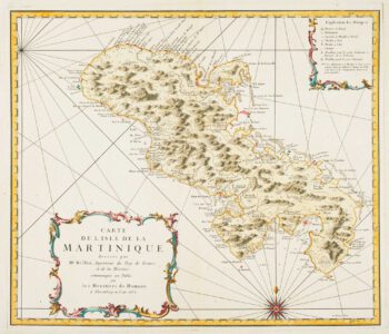
Detailed map of Martinique published during the Seven Years’ War
£600BELLIN, Jacques-Nicolas.
Published In 1762
Stock No. 14635 -

Early 18th century map of Martinique
£250FER, Nicolas de.
Published In 1704
Stock No. 18419 -

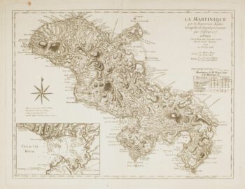
Map of 18th-century Martinique
£550JEFFERYS, Thomas.
Published In 1779
Stock No. 12317 -

18th century map of Martinique
£650COVENS & MORTIER.
Published In 1740
Stock No. 12311 -

An uncommon 19th century Spanish sea chart of the Dominican Republic
£100MOUCHEZ, Amédée Ernest Barthémy.
Published In 1865
Stock No. 11846