- Reset all
- Aegean Islands
- Argentina
- Bering Strait
- Berkshire
- Burma
- Canada
- Canary Islands
- Celestial
- Cheshire
- Denmark
- Devon
- Eastern Europe
- Eastern Seaboard Maps
- Elba
- France
- Georgia
- Gulf States
- Hertfordshire
- Holy Land
- Lancashire
- Latvia and Estonia
- Leinster
- Madeira
- Morocco
- Netherlands
- New York
- North America Maps
- Northamptonshire
- Nottinghamshire
- Prints
- Russia
- Solar System
- Surrey
- Tartary
- Trentino
- Ukraine
- United States
- Vietnam
- Warwickshire
- Westmorland
- World and Continents
- World Maps
Showing 13–24 of 704 results
-

Vancouver’s mapping of the Pacific North West
£350VANCOUVER, Capt. George.
Published In 1820
Stock No. 24534 -

A scarce map of the Holy Land in the 18th century
£250FER, Nicolas de.
Published In 1707
Stock No. 24525 -

A scarce map of the Holy Land in Biblical times
£250FER, Nicolas de.
Published In 1707
Stock No. 24524 -

The uncommon Spanish edition of Blaeu’s map of Hertfordshire
£450BLAEU, Johannes.
Published In 1662
Stock No. 24521 -

Seven scarce Italian playing cards depicting Russia
£480Anonymous.
Published In 1790
Stock No. 24360 -

Chart of the Zodiac sign Cancer
£275BLUNT, Charles F.
Published In 1845
Stock No. 24288 -

A 16th century town plan of Tangier
£220VALEGIO, Francesco.
Published In 1598
Stock No. 24217 -

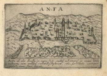
A 16th century town plan of Casablanca
£240VALEGIO, Francesco.
Published In 1598
Stock No. 24215 -

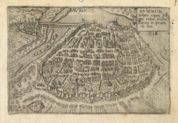
A 16th century town plan of Avignon
£150VALEGIO, Francesco.
Published In 1598
Stock No. 24211 -
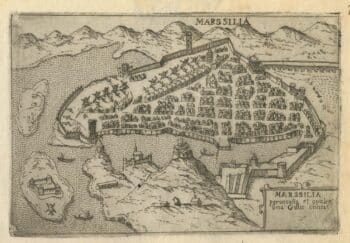
A 16th century town plan of Marseilles
£200VALEGIO, Francesco.
Published In 1598
Stock No. 24210 -

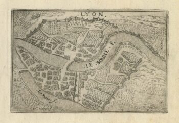
A 16th century town plan of Lyon
£150VALEGIO, Francesco.
Published In 1598
Stock No. 24209 -
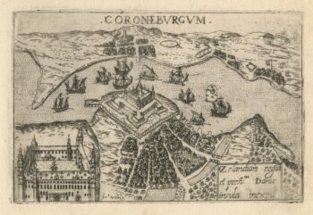
A 16th century town plan of Helsingor
£160VALEGIO, Francesco.
Published In 1598
Stock No. 24200