- Reset all
- Afghanistan
- Africa Continent
- Bering Strait
- Black Sea
- Bolivia
- Books about Maps
- Bristol
- Calabria
- Celestial
- Central Asia Maps
- China
- Emilia Romagna
- Europe
- Far East
- Grenada
- Hispaniola
- Hungary
- Italy
- Kent
- Lincolnshire
- London Environs
- Maritime
- Martinique
- North America
- Oxfordshire
- Pacific and Australasia
- Pennsylvania
- Pictorial Maps
- Piedmont
- Poland
- Provence
- Prussia
- Sardinia
- Scientific Instruments
- Scotland Maps
- Shropshire
- Somerset
- South Africa
- South America
- Southern Italy
- Staffordshire
- Syria
- Texas
- Tibet
- Trinidad
- United States Maps
- West Coast
- Worcestershire
- Zodiac
Showing 25–36 of 1607 results
-

A rare 16th century Italian plan of Famagusta
£950VALEGIO, Francesco.
Published In 1598
Stock No. 24148 -

18th century decorative map of Italy
£550SEUTTER, Matth?us.
Published In 1740
Stock No. 24614 -

A mid-18th century map of North America
£850LOTTER, Tobias Conrad.
Published In 1765
Stock No. 24610 -

16th century Dutch map of Switzerland
£800ORTELIUS, Abraham.
Published In 1575
Stock No. 21809 -

A late-Georgian map of the environs of London
£650CRUCHLEY, George Frederick.
Published In 1827
Stock No. 15495 -

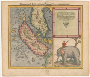
Woodblock map of Sumatra and the Malay Peninsula
£495MUNSTER, Sebastian.
Published In 1588
Stock No. 24584 -

16th century woodblock map of Silesia
£300MUNSTER, Sebastian.
Published In 1572
Stock No. 24582 -

16th century woodblock map of Slovenia and Croatia
£375MUNSTER, Sebastian.
Published In 1572
Stock No. 24581 -

16th century woodblock map of France
£380MUNSTER, Sebastian.
Published In 1572
Stock No. 24580 -
Munster’s map of the Iberian Peninsula
£400MUNSTER, Sebastian.
Published In 1572
Stock No. 24579 -

A 16th century woodcut prospect of Rome
£400MUNSTER, Sebastian.
Published In 1572
Stock No. 24577 -
A 16th century woodcut map of Greece
£380MUNSTER, Sebastian.
Published In 1572
Stock No. 24576