- Reset all
- Afghanistan
- Africa Continent
- Bering Strait
- Black Sea
- Bolivia
- Books about Maps
- Bristol
- Calabria
- Celestial
- Central Asia Maps
- China
- Emilia Romagna
- Europe
- Far East
- Grenada
- Hispaniola
- Hungary
- Italy
- Kent
- Lincolnshire
- London Environs
- Maritime
- Martinique
- North America
- Oxfordshire
- Pacific and Australasia
- Pennsylvania
- Pictorial Maps
- Piedmont
- Poland
- Provence
- Sardinia
- Scientific Instruments
- Scotland Maps
- Shropshire
- Somerset
- South Africa
- South America
- Southern Italy
- Staffordshire
- Syria
- Texas
- Tibet
- Trinidad
- United States Maps
- West Coast
- Worcestershire
- Zodiac
Showing 1–12 of 1537 results
-

A geological map of the Duchy of Tyrol
£2,350STOTTER, Michael.
Published In 1851
Stock No. 23050 -

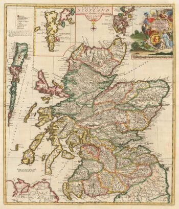
A scarce map of Scotland
£1,000BROWNE, Christopher.
Published In 1721
Stock No. 24436 -

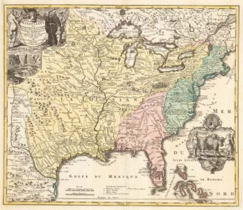
‘The Buffalo map’ of the Mississippi
£2,000HOMANN, Johann Baptist.
Published In 1720
Stock No. 24427 -

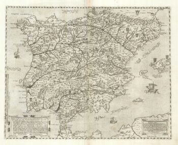
A two-sheet ‘Lafreri-School’ important map of Iberia
£9,750FORLANI, Paolo.
Published In 1567
Stock No. 24477 -

A 17th century chart of the eastern Mediterranean in fine colour.
£1,600DE WIT, Frederick.
Published In 1745
Stock No. 24490 -

de Hooghe’s spectacular chart of the Mediterranean Sea
£36,500HOOGHE, Romeyn de.
Published In 1694
Stock No. 24488 -

A view of the Battle of Lepanto engraved in 1572
£2,500CAVALIERI, Giovanni Battista de'.
Published In 1647
Stock No. 24486 -

Uncommon 16th century Italian map of Cyprus
£1,600ROSACCIO, Giuseppe.
Published In 1598
Stock No. 24538 -

A rare lifetime printing of Blaeu’s view of Vesuvius erupting in 1631
£1,400BLAEU, Johannes.
Published In 1663
Stock No. 24506 -

A monumental 18th century wall map of Switzerland on four sheets
£6,500SCHEUCHZER, Johann Jakob.
Published In 1712
Stock No. 24499 -

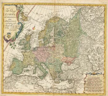
18th century map of Europe
£440EULER, Leonhard.
Published In 1760
Stock No. 24111 -

An instructional card explaining shipboard directions
£220Anonymous.
Published In 1840
Stock No. 24472