Showing 1–12 of 67 results
-

Vrients’s scarce map of England, Wales & Ireland
£4,250VRIENTS, Jan Baptist.
Published In 1612
Stock No. 20271 -

A scarce two-sheet map of England and Wales with side panels
£3,000WILLDEY, George.
Published In 1715
Stock No. 24165 -
An important 16th century plan of Angra
£2,800LINSCHOTEN, Jan Huygen van.
Published In 1595
Stock No. 23737 -

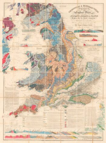
A detailed geological map of England and Wales
£1,500KNIPE, James Alexander.
Published In 1870
Stock No. 23418 -

Speed’s map of the wars of England
£1,800SPEED, John.
Published In 1665
Stock No. 23791 -

An aerial relief map of Afghanistan during the Great Game
£2,500JOHNSTON, W. & A.K.
Published In 1885
Stock No. 23565 -

Miniature map of the East Midlands
£60PERROT, Aristide Michel.
Published In 1828
Stock No. 23304 -

Read’s map of Napoleon’s exile on St Helena, Second State
£1,200READ, R.P.
Published In 1817
Stock No. 22662 -

Napoleon in exile on St Helena
£1,400READ, R.P.
Published In 1815
Stock No. 22661 -

Read’s map of Napoleon’s exile on St Helena, First State
£1,200READ, R.P.
Published In 1815
Stock No. 22660 -

England divided into the Saxon Heptarchy
£380SEUTTER, Matthaus.
Published In 1740
Stock No. 22311 -

A leaf of Saxton’s ‘Traveller’s Guide’ of England and Wales
£900SAXTON, Christopher.
Published In 1700
Stock No. 24050