- Reset all
- Afghanistan
- Argentina
- Atlases and Books
- Beijing
- Bering Strait
- Bolivia
- Books
- Derbyshire
- Dorset
- Ecuador
- Essex
- French Regions
- Iceland
- Ionian Islands
- Italy Maps
- Korea
- Latvia and Estonia
- London
- Middlesex
- Miscellany
- North Africa
- Northern Europe
- Pictorial Maps
- Seychelles
- Spain
- Wales
- West Coast
- West Indies
- Wind Roses
- World
Showing 1–12 of 628 results
-

Ortelius’s pocket atlas with the Galle maps in fine colour
£14,000ORTELIUS, Abraham.
Published In 1595
Stock No. 24476 -

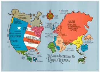
A serio-comic map satirising Ronald Reagan’s view of the World
£650HORSEY, David.
Published In 1984
Stock No. 24474 -

A Victorian game map of the world.
£5,500JONES, Thomas Henry.
Published In 1845
Stock No. 24423 -

Ruysch’s 1507 world map, with the earliest obtainable depiction of the Americas
£260,000RUYSCH, Johann.
Published In 1507
Stock No. 22807 -

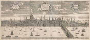
A rare three-sheet prospect of London
£20,000NICHOLLS, Sutton.
Published In 1710
Stock No. 22537 -

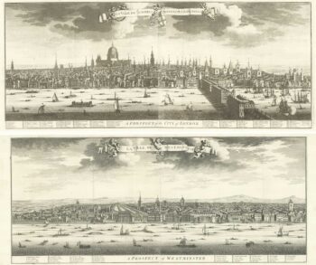
A magnificient pair of early 18th century prospects of London and Westminster
£18,000KIP, Johannes.
Published In 1720
Stock No. 18752 -

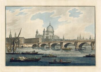
18th century view of the City from the Thames
£1,500FARINGTON, Joseph.
Published In 1790
Stock No. 24557 -

A prospect of Pre-Fire London after Visscher
£3,250DE JONGHE, Clement.
Published In 1660
Stock No. 24489 -

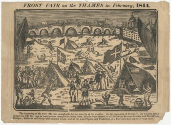
The last London Frost Fair, held in 1814
£1,200Anonymous.
Published In 1815
Stock No. 24537 -

A rare two volume geographical lexicon
£17,500LASOR A VAREA, Alphonsus.
Published In 1713
Stock No. 24516 -

London by one of England’s foremost maritime artists
£7,000WYLLIE, William Lionel.
Published In 1884
Stock No. 24497 -
One of the earliest world maps available to the collector
£15,000SCHEDEL, D. Hartmann.
Published In 1493
Stock No. 24528