
- Reset all
- Afghanistan
- Argentina
- Atlases and Books
- Beijing
- Bering Strait
- Bolivia
- Books
- Derbyshire
- Dorset
- Ecuador
- French Regions
- Holy Land
- Iceland
- Ionian Islands
- Italy Maps
- Latvia and Estonia
- London
- Middlesex
- Moscow
- North Africa
- Pictorial Maps
- Seychelles
- Spain
- Wales
- West Coast
- West Indies
- Wind Roses
- World
Showing 1–12 of 604 results
-
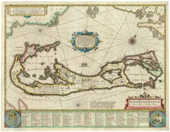
Richard Norwood’s map of Bermuda
£1,000HONDIUS, Henricus.
Published In 1633
Stock No. 24607 -

An unusual 18th century map of the Holy Land
£800SEUTTER, Matth?us.
Published In 1745
Stock No. 24605 -

Blaeu’s classic 17th century map of Iceland
£1,200BLAEU, Willem Janszoon.
Published In 1635
Stock No. 24604 -

A plan of Jerusalem after Adrichom
£750SEUTTER, Matth?us.
Published In 1730
Stock No. 24600 -

An early woodcut map of the Holy Land
£850MUNSTER, Sebastian.
Published In 1552
Stock No. 24569 -

Munster’s classic woodcut map of Italy
£850MUNSTER, Sebastian.
Published In 1572
Stock No. 24562 -

A classic 16th century Dutch map of Italy
£1,400ORTELIUS, Abraham.
Published In 1572
Stock No. 24552 -

17th century prospect of Biblical Jerusalem
£1,000DAPPER, Olfert.
Published In 1677
Stock No. 24540 -
18th century Italian map of the West Indies
£550CASSINI, Giovanni Maria.
Published In 1798
Stock No. 24532 -

A detailed plan of Kensington Gardens and Hyde Park
£750ORDNANCE SURVEY.
Published In 1906
Stock No. 24529 -

A map illustrating the British dominance of the seas
£450LONDON GEOGRAPHICAL INSTITUTE.
Published In 1922
Stock No. 24508 -

The Peutinger Table, one of the few surviving examples of Roman cartography
£2,000JANSSON, Jan.
Published In 1700
Stock No. 24492


