Showing 1–12 of 838 results
-
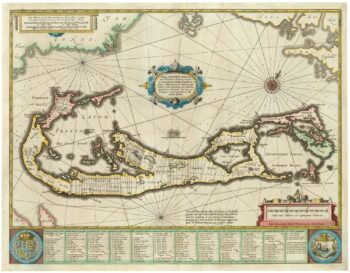
Richard Norwood’s map of Bermuda
£1,000HONDIUS, Henricus.
Published In 1633
Stock No. 24607 -

An unusual 18th century map of the Holy Land
£800SEUTTER, Matth?us.
Published In 1745
Stock No. 24605 -

Blaeu’s classic 17th century map of Iceland
£1,200BLAEU, Willem Janszoon.
Published In 1635
Stock No. 24604 -

A plan of Jerusalem after Adrichom
£750SEUTTER, Matth?us.
Published In 1730
Stock No. 24600 -

16th century woodcut map of Sri Lanka as Taprobana
£500MUNSTER, Sebastian.
Published In 1574
Stock No. 24578 -

An early woodcut map of the Holy Land
£850MUNSTER, Sebastian.
Published In 1552
Stock No. 24569 -

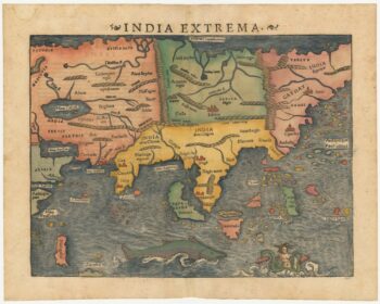
The first printed map of Asia
£1,850MUNSTER, Sebastian.
Published In 1572
Stock No. 24565 -

The English edition of Du Halde’s map of Guangdong
£1,600DU HALDE, Johann Baptiste.
Published In 1738
Stock No. 24558 -

A large and detailed 19th century map of India
£750WALKER, John.
Published In 1829
Stock No. 24543 -

17th century prospect of Biblical Jerusalem
£1,000DAPPER, Olfert.
Published In 1677
Stock No. 24540 -

18th century Italian map of the West Indies
£550CASSINI, Giovanni Maria.
Published In 1798
Stock No. 24532 -

A detailed plan of Kensington Gardens and Hyde Park
£750ORDNANCE SURVEY.
Published In 1906
Stock No. 24529