Showing all 12 results
-

An aerial relief map of Afghanistan during the Great Game
£2,500JOHNSTON, W. & A.K.
Published In 1885
Stock No. 23565 -

Speed’s maps of the Channel Islands, Farne and Holy Island
£750SPEED, John.
Published In 1627
Stock No. 23822 -

Map of the Channel Islands of Jersey & Guersney
£125TALLIS, John.
Published In 1851
Stock No. 23517 -

Maps of British islands from the first English Edition of the ‘Atlas Minor’
£140HONDIUS, Jodocus.
Published In 1635
Stock No. 22449 -

A scarce 17th century French map of Martinique
£400MARIETTE, Pierre.
Published In 1650
Stock No. 21841 -

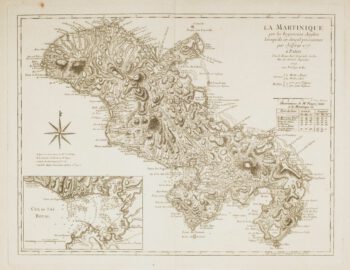
Map of Martinique
£200RASPE, Gabriel Nikolaus.
Published In 1762
Stock No. 19677 -

18th century map of Martinique in fine colour
£550SEUTTER, Matthaus.
Published In 1730
Stock No. 19343 -

Scarce map of the Channel Islands
£180REILLY, Franz Johann Joseph von.
Published In 1789
Stock No. 17206 -

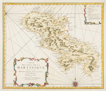
Detailed map of Martinique published during the Seven Years’ War
£600BELLIN, Jacques-Nicolas.
Published In 1762
Stock No. 14635 -

Early 18th century map of Martinique
£250FER, Nicolas de.
Published In 1704
Stock No. 18419 -

Map of 18th-century Martinique
£550JEFFERYS, Thomas.
Published In 1779
Stock No. 12317 -

18th century map of Martinique
£650COVENS & MORTIER.
Published In 1740
Stock No. 12311