Showing 1–12 of 32 results
-

A 16th century map of the colony of New Spain
£750ORTELIUS, Abraham.
Published In 1584
Stock No. 24448 -

A serio-comic map of Europe with the Russian octopus
£4,750GROSSI, Augusto.
Published In 1878
Stock No. 24393 -

Decorative 18th century map of Norway
£460HOMANN, Johann Baptist.
Published In 1720
Stock No. 24171 -

An aerial relief map of Afghanistan during the Great Game
£2,500JOHNSTON, W. & A.K.
Published In 1885
Stock No. 23565 -

A French serio-comic map of Europe for the Great War
£1,850CRETE, B.
Published In 1915
Stock No. 23347 -

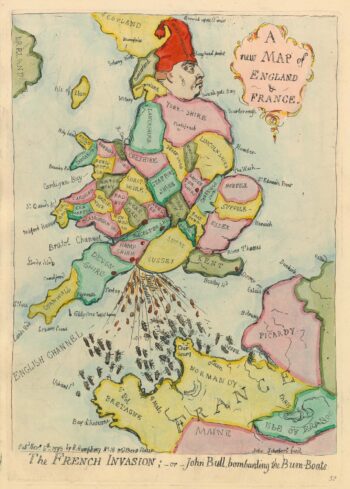
Caricature map of England in danger of invasion, from Gillray’s cruder output
£1,250GILLRAY, James.
Published In 1851
Stock No. 24158 -

An 18th century map of the West Indies
£290JEFFERYS, Thomas.
Published In 1768
Stock No. 23673 -

Ortelius’s antique map of the West Indies and Culiac?n in Mexico
£1,250ORTELIUS, Abraham.
Published In 1584
Stock No. 23599 -

The Muscovy Company whaling at Svalbard
£950EDGE, Thomas.
Published In 1625
Stock No. 23464 -

17th century old maps of the West Indian Islands
£1,200HONDIUS, Jodocus.
Published In 1623
Stock No. 23456 -

The English possessions in the West Indies
£850SENEX, John.
Published In 1721
Stock No. 23423 -

A rare Italian serio-comic map of Europe in 1871
£20,000MANFREDO, Manfredi.
Published In 1871
Stock No. 23283